Celano elevation
Celano (Abruzzo, Provincia dell' Aquila), Italy elevation is 742 meters and Celano elevation in feet is 2434 ft above sea level [src 1]. Celano is a seat of a third-order administrative division (feature code) with elevation that is 420 meters (1378 ft) bigger than average city elevation in Italy.
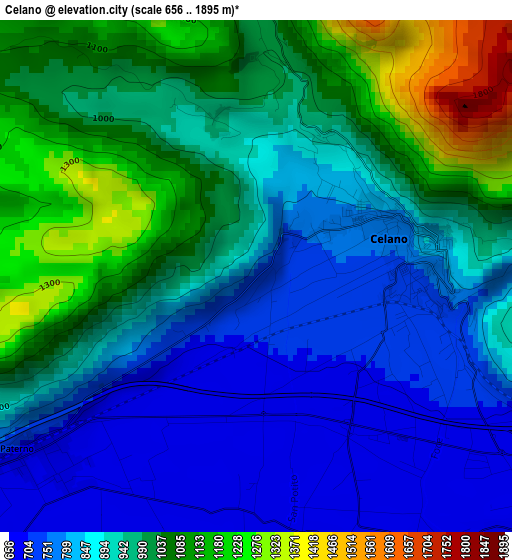
Below is the Elevation map of Celano, which displays elevation range with different colors. Scale of the first map is from 656 to 1895 m (2152 to 6217 ft) with average elevation of 931.8 meters (=3057 ft) [note 1]
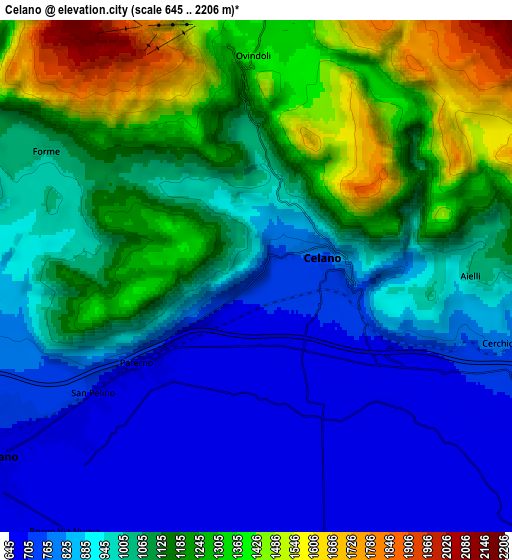
These maps also provides idea of topography and contour of this city, they are displayed at different zoom levels. More info about maps, scale and edge coordinates you can find below images.
| \ | Map #1 | Map #2 | Topo.Map |
| Scale [m] | 656..1895 m | 645..2206 m | × |
| Scale [ft] | 2152..6217 ft | 2116..7238 ft | × |
| Average | 931.8 m = 3057 ft | 1034.4 m = 3394 ft | × |
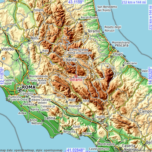
| Width | 7.25 km = 4.5 mi | 14.51 km = 9 mi | 232.1 km = 144.2 mi |
| Height | 7.25 km = 4.5 mi | 14.51 km = 9 mi | 232.1 km = 144.2 mi |
| ↑Max Latitude | 42.113378° | 42.145969° | 43.1159° |
| Latitude at center | 42.08077° | 42.08077° | 42.08077° |
| ↓Min Latitude | 42.048145° | 42.015504° | 41.02848° |
| ← Min Longitude | 13.473055° | 13.429109° | 12.11075° |
| Longitude center | 13.517° | 13.517° | 13.517° |
| →Max Longitude | 13.560945° | 13.604891° | 14.92325° |
Nearby cities:
Cities around Celano sort by population:
• Avezzano elevation 688 m
9.4 km,  232°
232°
• Trasacco 688 m
13.8 km,  174°
174°
• Luco dei Marsi 662 m
14 km,  194°
194°
• San Benedetto dei Marsi 679 m
12 km,  132°
132°
• Pescina 716 m
12.8 km,  119°
119°
• Magliano De'Marsi 726 m
12.7 km,  275°
275°
• Cerchio 802 m
7.1 km,  105°
105°
• Rocca di Mezzo 1282 m
13.7 km,  0°
0°
• Collarmele 834 m
9.3 km,  104°
104°
• Ovindoli 1367 m
6.3 km,  359°
359°
• Aielli 1030 m
6.1 km,  89°
89°
• Massa d'Albe-Corona 855 m
10.5 km,  286°
286°
Multilingual:
 En español:
Celano elevación 742 m.
 En France:
Celano élévation 742 m.


Sources and notes:
- [note 1] Map square and city borders are not equal. Map elevation data is calculated only from area inside that square.
- [src 1] Elevation data from geonames database provided with same terms of usage.
- [src 2] The elevation map of Celano is generated using elevation data from NASA's 3 arcsec (90m) resolution SRTM data.
- [src 3] Base (background) map © OpenStreetMap contributors tiles are generated by Geofabrik and OpenTopoMap.
Copyright & License:
This Celano Elevation Map is licensed under CC BY-SA. You may reuse any part from this page, if you give a proper credit by linking to this URL:
 More info on terms of use page.