Ovindoli elevation
Ovindoli (Abruzzo, Provincia dell' Aquila), Italy elevation is 1367 meters and Ovindoli elevation in feet is 4485 ft above sea level [src 1]. Ovindoli is a seat of a third-order administrative division (feature code) with elevation that is 1045 meters (3428 ft) bigger than average city elevation in Italy.
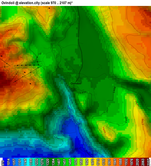
Below is the Elevation map of Ovindoli, which displays elevation range with different colors. Scale of the first map is from 970 to 2107 m (3182 to 6913 ft) with average elevation of 1483.3 meters (=4866 ft) [note 1]
These maps also provides idea of topography and contour of this city, they are displayed at different zoom levels. More info about maps, scale and edge coordinates you can find below images.
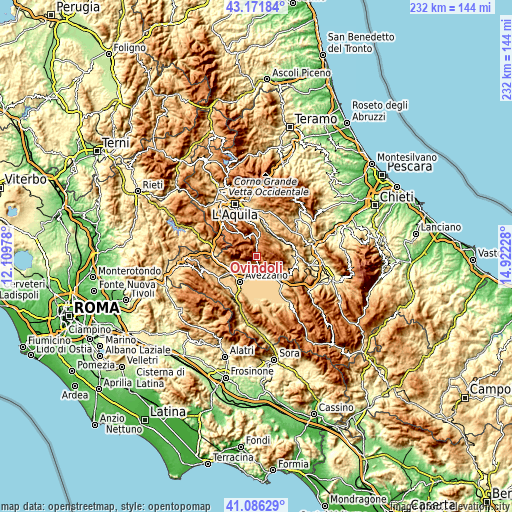
| \ | Map #1 | Topo.Map |
| Scale [m] | 970..2107 m | × |
| Scale [ft] | 3182..6913 ft | × |
| Average | 1483.3 m = 4866 ft | × |
| Width | 7.25 km = 4.5 mi | 231.9 km = 144.1 mi |
| Height | 7.25 km = 4.5 mi | 231.9 km = 144.1 mi |
| ↑Max Latitude | 42.170229° | 43.17184° |
| Latitude at center | 42.13765° | 42.13765° |
| ↓Min Latitude | 42.105055° | 41.08629° |
| ← Min Longitude | 13.472085° | 12.10978° |
| Longitude center | 13.51603° | 13.51603° |
| →Max Longitude | 13.559975° | 14.92228° |
Nearby cities:
Cities around Ovindoli sort by population:
• Celano elevation 742 m
6.3 km,  179°
179°
• Magliano De'Marsi 726 m
13.6 km,  247°
247°
• Cerchio 802 m
10.8 km,  139°
139°
• Rocca di Mezzo 1282 m
7.4 km,  1°
1°
• Collarmele 834 m
12.5 km,  133°
133°
• Aielli 1030 m
8.8 km, 135°
• Massa d'Albe-Corona 855 m
10.6 km, 251°
• Secinaro 735 m
13.7 km,  83°
83°
• Fontecchio 664 m
12.7 km,  35°
35°
• Rocca di Cambio 1388 m
11.3 km,  348°
348°
• Tione degli Abruzzi 588 m
12.3 km,  53°
53°
• Vallecupa 676 m
13.8 km,  20°
20°
Multilingual:
 En español:
Ovindoli elevación 1367 m.
 En France:
Ovindoli élévation 1367 m.
 Auf Deutsch:
Ovindoli höhe über dem Meeresspiegel ist 1367 m.

Sources and notes:
- [note 1] Map square and city borders are not equal. Map elevation data is calculated only from area inside that square.
- [src 1] Elevation data from geonames database provided with same terms of usage.
- [src 2] The elevation map of Ovindoli is generated using elevation data from NASA's 3 arcsec (90m) resolution SRTM data.
- [src 3] Base (background) map © OpenStreetMap contributors tiles are generated by Geofabrik and OpenTopoMap.
Copyright & License:
This Ovindoli Elevation Map is licensed under CC BY-SA. You may reuse any part from this page, if you give a proper credit by linking to this URL:
 More info on terms of use page.