Cerchio elevation
Cerchio (Abruzzo, Provincia dell' Aquila), Italy elevation is 802 meters and Cerchio elevation in feet is 2631 ft above sea level [src 1]. Cerchio is a seat of a third-order administrative division (feature code) with elevation that is 480 meters (1575 ft) bigger than average city elevation in Italy.
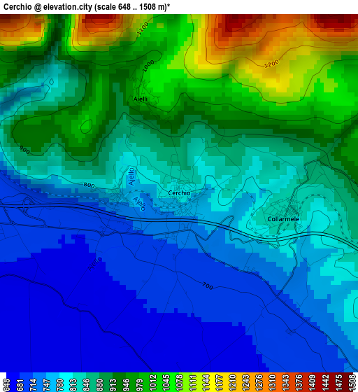
Below is the Elevation map of Cerchio, which displays elevation range with different colors. Scale of the first map is from 648 to 1508 m (2126 to 4948 ft) with average elevation of 849 meters (=2785 ft) [note 1]
These maps also provides idea of topography and contour of this city, they are displayed at different zoom levels. More info about maps, scale and edge coordinates you can find below images.
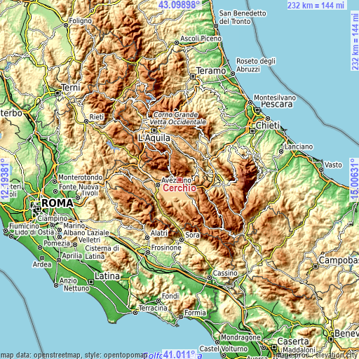
| \ | Map #1 | Topo.Map |
| Scale [m] | 648..1508 m | × |
| Scale [ft] | 2126..4948 ft | × |
| Average | 849 m = 2785 ft | × |
| Width | 7.26 km = 4.5 mi | 232.2 km = 144.3 mi |
| Height | 7.26 km = 4.5 mi | 232.2 km = 144.3 mi |
| ↑Max Latitude | 42.096187° | 43.09898° |
| Latitude at center | 42.06357° | 42.06357° |
| ↓Min Latitude | 42.030937° | 41.011° |
| ← Min Longitude | 13.556115° | 12.19381° |
| Longitude center | 13.60006° | 13.60006° |
| →Max Longitude | 13.644005° | 15.00631° |
Nearby cities:
Cities around Cerchio sort by population:
• Celano elevation 742 m
7.1 km,  285°
285°
• San Benedetto dei Marsi 679 m
6.5 km,  162°
162°
• Pescina 716 m
6.1 km,  136°
136°
• Ortucchio 671 m
12.6 km, 162°
• Castelvecchio Subequo 480 m
12.9 km,  55°
55°
• Collarmele 834 m
2.2 km,  99°
99°
• Ovindoli 1367 m
10.8 km,  319°
319°
• Aielli 1030 m
2.1 km,  339°
339°
• Secinaro 735 m
11.8 km,  34°
34°
• Castel di Ieri 524 m
13 km, 64°
• Gagliano Aterno 654 m
10.8 km,  49°
49°
• Ortona dei Marsi 980 m
12.9 km,  124°
124°
Multilingual:
 En español:
Cerchio elevación 802 m.
 En France:
Cerchio élévation 802 m.


Sources and notes:
- [note 1] Map square and city borders are not equal. Map elevation data is calculated only from area inside that square.
- [src 1] Elevation data from geonames database provided with same terms of usage.
- [src 2] The elevation map of Cerchio is generated using elevation data from NASA's 3 arcsec (90m) resolution SRTM data.
- [src 3] Base (background) map © OpenStreetMap contributors tiles are generated by Geofabrik and OpenTopoMap.
Copyright & License:
This Cerchio Elevation Map is licensed under CC BY-SA. You may reuse any part from this page, if you give a proper credit by linking to this URL:
 More info on terms of use page.