Vallecupa elevation
Vallecupa (Abruzzo, Provincia dell' Aquila), Italy elevation is 676 meters and Vallecupa elevation in feet is 2218 ft above sea level [src 1]. Vallecupa is a seat of a third-order administrative division (feature code) with elevation that is 354 meters (1161 ft) bigger than average city elevation in Italy.
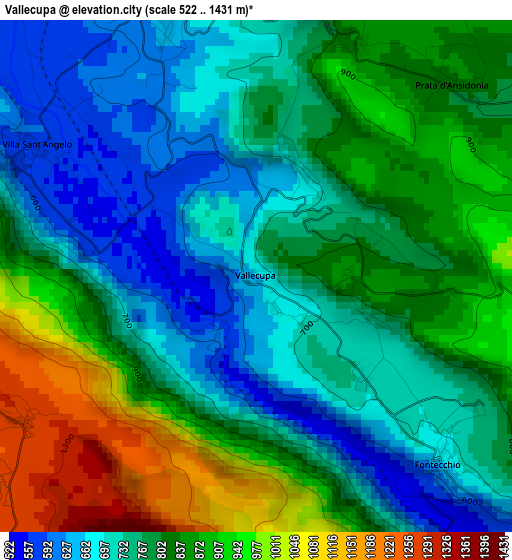
Below is the Elevation map of Vallecupa, which displays elevation range with different colors. Scale of the first map is from 522 to 1431 m (1713 to 4695 ft) with average elevation of 799.1 meters (=2622 ft) [note 1]
These maps also provides idea of topography and contour of this city, they are displayed at different zoom levels. More info about maps, scale and edge coordinates you can find below images.
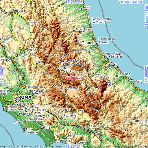
| \ | Map #1 | Topo.Map |
| Scale [m] | 522..1431 m | × |
| Scale [ft] | 1713..4695 ft | × |
| Average | 799.1 m = 2622 ft | × |
| Width | 7.23 km = 4.5 mi | 231.5 km = 143.8 mi |
| Height | 7.23 km = 4.5 mi | 231.5 km = 143.8 mi |
| ↑Max Latitude | 42.286179° | 43.28593° |
| Latitude at center | 42.25366° | 42.25366° |
| ↓Min Latitude | 42.221124° | 41.20421° |
| ← Min Longitude | 13.530725° | 12.16842° |
| Longitude center | 13.57467° | 13.57467° |
| →Max Longitude | 13.618615° | 14.98092° |
Nearby cities:
Cities around Vallecupa sort by population:
• San Demetrio Ne' Vestini elevation 643 m
4.3 km,  338°
338°
• Barisciano 935 m
8 km,  9°
9°
• Rocca di Mezzo 1282 m
7.2 km,  220°
220°
• Poggio Picenze 737 m
8 km, 339°
• Villa Sant'Angelo 589 m
3.6 km,  301°
301°
• San Pio delle Camere 763 m
7.5 km,  62°
62°
• Prata d'Ansidonia 835 m
3.9 km,  45°
45°
• Fontecchio 664 m
3.7 km,  135°
135°
• Rocca di Cambio 1388 m
7.3 km,  255°
255°
• Sant'Eusanio Forconese 590 m
5.8 km,  313°
313°
• Caporciano 825 m
8.2 km,  92°
92°
• Tione degli Abruzzi 588 m
7.5 km, 137°
Multilingual:
 En español:
Vallecupa elevación 676 m.
 En France:
Vallecupa élévation 676 m.
 Auf Deutsch:
Vallecupa höhe über dem Meeresspiegel ist 676 m.

Sources and notes:
- [note 1] Map square and city borders are not equal. Map elevation data is calculated only from area inside that square.
- [src 1] Elevation data from geonames database provided with same terms of usage.
- [src 2] The elevation map of Vallecupa is generated using elevation data from NASA's 3 arcsec (90m) resolution SRTM data.
- [src 3] Base (background) map © OpenStreetMap contributors tiles are generated by Geofabrik and OpenTopoMap.
Copyright & License:
This Vallecupa Elevation Map is licensed under CC BY-SA. You may reuse any part from this page, if you give a proper credit by linking to this URL:
 More info on terms of use page.