Tornimparte elevation
Tornimparte (Abruzzo, Provincia dell' Aquila), Italy elevation is 874 meters and Tornimparte elevation in feet is 2867 ft above sea level [src 1]. Tornimparte is a populated place (feature code) with elevation that is 552 meters (1811 ft) bigger than average city elevation in Italy.
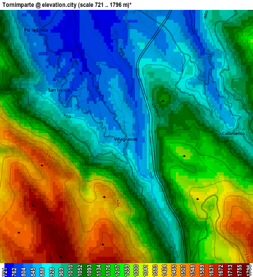
Below is the Elevation map of Tornimparte, which displays elevation range with different colors. Scale of the first map is from 721 to 1796 m (2365 to 5892 ft) with average elevation of 1121.1 meters (=3678 ft) [note 1]
These maps also provides idea of topography and contour of this city, they are displayed at different zoom levels. More info about maps, scale and edge coordinates you can find below images.
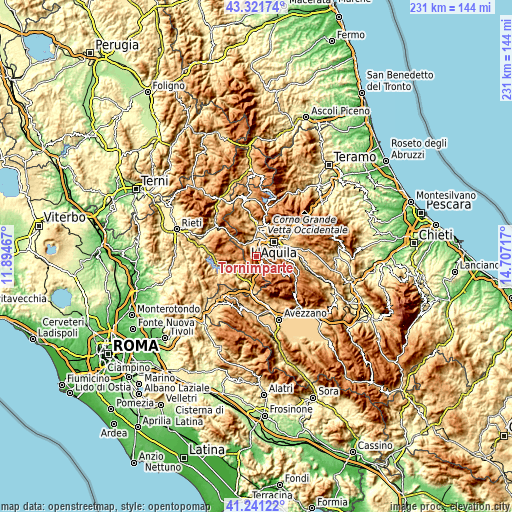
| \ | Map #1 | Topo.Map |
| Scale [m] | 721..1796 m | × |
| Scale [ft] | 2365..5892 ft | × |
| Average | 1121.1 m = 3678 ft | × |
| Width | 7.23 km = 4.5 mi | 231.3 km = 143.7 mi |
| Height | 7.23 km = 4.5 mi | 231.3 km = 143.7 mi |
| ↑Max Latitude | 42.32257° | 43.32174° |
| Latitude at center | 42.29007° | 42.29007° |
| ↓Min Latitude | 42.257553° | 41.24122° |
| ← Min Longitude | 13.256975° | 11.89467° |
| Longitude center | 13.30092° | 13.30092° |
| →Max Longitude | 13.344865° | 14.70717° |
Nearby cities:
Cities around Tornimparte sort by population:
• L'Aquila elevation 728 m
10.5 km,  50°
50°
• Coppito 655 m
9.3 km,  22°
22°
• Preturo 687 m
9.8 km,  357°
357°
• Corvaro 841 m
9.9 km,  197°
197°
• Sassa 684 m
6.9 km, 358°
• Progetto Case Coppito 3 692 m
9 km,  9°
9°
• Progetto Case Sassa Nsi 656 m
8.5 km, 7°
• Pianola 743 m
9.2 km,  66°
66°
• Cominio 631 m
11.1 km,  77°
77°
• Lucoli 954 m
3.1 km,  88°
88°
• Villagrande 875 m
0.6 km,  352°
352°
• Scoppito 753 m
9.5 km,  338°
338°
Multilingual:
 En español:
Tornimparte elevación 874 m.
 En France:
Tornimparte élévation 874 m.
 Auf Deutsch:
Tornimparte höhe über dem Meeresspiegel ist 874 m.

Sources and notes:
- [note 1] Map square and city borders are not equal. Map elevation data is calculated only from area inside that square.
- [src 1] Elevation data from geonames database provided with same terms of usage.
- [src 2] The elevation map of Tornimparte is generated using elevation data from NASA's 3 arcsec (90m) resolution SRTM data.
- [src 3] Base (background) map © OpenStreetMap contributors tiles are generated by Geofabrik and OpenTopoMap.
Copyright & License:
This Tornimparte Elevation Map is licensed under CC BY-SA. You may reuse any part from this page, if you give a proper credit by linking to this URL:
 More info on terms of use page.