Semonte-Casamorcia elevation
Semonte-Casamorcia (Umbria, Provincia di Perugia), Italy elevation is 439 meters and Semonte-Casamorcia elevation in feet is 1440 ft above sea level [src 1]. Semonte-Casamorcia is a populated place (feature code) with elevation that is 117 meters (384 ft) bigger than average city elevation in Italy.
Below is the Elevation map of Semonte-Casamorcia, which displays elevation range with different colors. Scale of the first map is from 389 to 969 m (1276 to 3179 ft) with average elevation of 571.6 meters (=1875 ft) [note 1]
These maps also provides idea of topography and contour of this city, they are displayed at different zoom levels. More info about maps, scale and edge coordinates you can find below images.
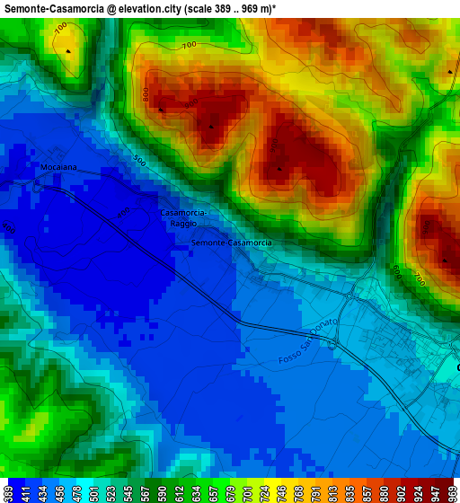
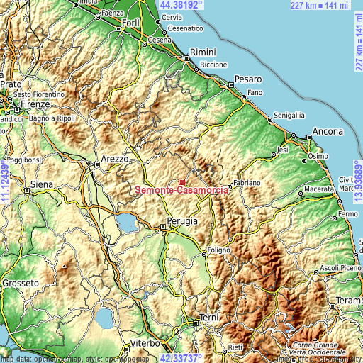
| \ | Map #1 | Topo.Map |
| Scale [m] | 389..969 m | × |
| Scale [ft] | 1276..3179 ft | × |
| Average | 571.6 m = 1875 ft | × |
| Width | 7.1 km = 4.4 mi | 227.3 km = 141.2 mi |
| Height | 7.1 km = 4.4 mi | 227.3 km = 141.2 mi |
| ↑Max Latitude | 43.400198° | 44.38192° |
| Latitude at center | 43.36826° | 43.36826° |
| ↓Min Latitude | 43.336305° | 42.33737° |
| ← Min Longitude | 12.486695° | 11.12439° |
| Longitude center | 12.53064° | 12.53064° |
| →Max Longitude | 12.574585° | 13.93689° |
Nearby cities:
Cities around Semonte-Casamorcia sort by population:
• Gubbio elevation 487 m
4 km,  120°
120°
• Umbertide 246 m
17.2 km,  245°
245°
• Padule-San Marco 454 m
7.7 km, 124°
• Sigillo 486 m
17.5 km,  103°
103°
• Cantiano 384 m
13.9 km,  34°
34°
• Pietralunga 548 m
11.1 km,  312°
312°
• Monte Grimano 751 m
12.1 km,  334°
334°
• Cipolleto 430 m
6.2 km,  142°
142°
• Stazione di Padule 413 m
9.6 km,  134°
134°
• Scheggia 598 m
11.6 km,  70°
70°
• Montone 429 m
16.8 km,  267°
267°
• Costacciaro 554 m
14.7 km,  94°
94°
Multilingual:
 En español:
Semonte-Casamorcia elevación 439 m.
 En France:
Semonte-Casamorcia élévation 439 m.
 Auf Deutsch:
Semonte-Casamorcia höhe über dem Meeresspiegel ist 439 m.
 На русском:
Semonte-Casamorcia высота над уровнем моря 439 м
Sources and notes:
- [note 1] Map square and city borders are not equal. Map elevation data is calculated only from area inside that square.
- [src 1] Elevation data from geonames database provided with same terms of usage.
- [src 2] The elevation map of Semonte-Casamorcia is generated using elevation data from NASA's 3 arcsec (90m) resolution SRTM data.
- [src 3] Base (background) map © OpenStreetMap contributors tiles are generated by Geofabrik and OpenTopoMap.
Copyright & License:
This Semonte-Casamorcia Elevation Map is licensed under CC BY-SA. You may reuse any part from this page, if you give a proper credit by linking to this URL:
 More info on terms of use page.