Costacciaro elevation
Costacciaro (Umbria, Provincia di Perugia), Italy elevation is 554 meters and Costacciaro elevation in feet is 1818 ft above sea level [src 1]. Costacciaro is a seat of a third-order administrative division (feature code) with elevation that is 232 meters (761 ft) bigger than average city elevation in Italy.
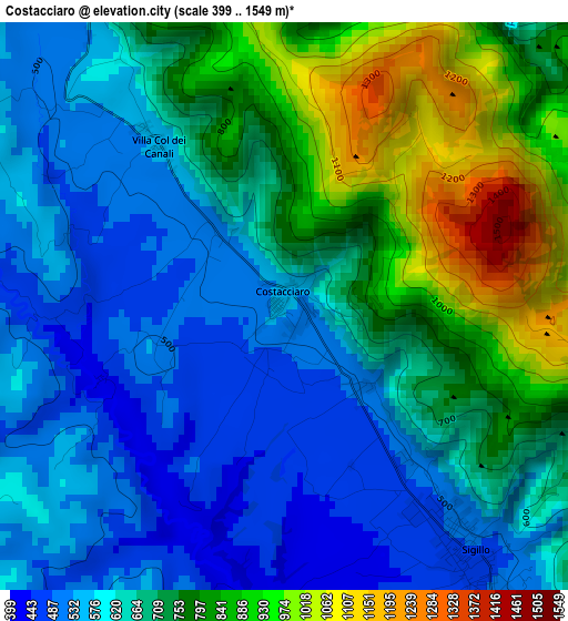
Below is the Elevation map of Costacciaro, which displays elevation range with different colors. Scale of the first map is from 399 to 1549 m (1309 to 5082 ft) with average elevation of 684.5 meters (=2246 ft) [note 1]
These maps also provides idea of topography and contour of this city, they are displayed at different zoom levels. More info about maps, scale and edge coordinates you can find below images.
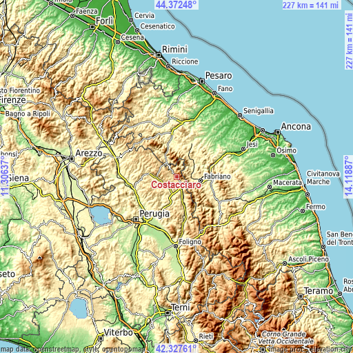
| \ | Map #1 | Topo.Map |
| Scale [m] | 399..1549 m | × |
| Scale [ft] | 1309..5082 ft | × |
| Average | 684.5 m = 2246 ft | × |
| Width | 7.11 km = 4.4 mi | 227.4 km = 141.3 mi |
| Height | 7.11 km = 4.4 mi | 227.4 km = 141.3 mi |
| ↑Max Latitude | 43.390603° | 44.37248° |
| Latitude at center | 43.35866° | 43.35866° |
| ↓Min Latitude | 43.3267° | 42.32761° |
| ← Min Longitude | 12.668675° | 11.30637° |
| Longitude center | 12.71262° | 12.71262° |
| →Max Longitude | 12.756565° | 14.11887° |
Nearby cities:
Cities around Costacciaro sort by population:
• Gubbio elevation 487 m
11.3 km,  265°
265°
• Gualdo Tadino 490 m
15.3 km,  159°
159°
• Sassoferrato 284 m
14.1 km,  55°
55°
• Semonte-Casamorcia 439 m
14.7 km, 274°
• Padule-San Marco 454 m
9 km,  248°
248°
• Sigillo 486 m
3.8 km,  143°
143°
• Osteria del Gatto 405 m
8.6 km, 162°
• Cantiano 384 m
14.2 km,  331°
331°
• Cipolleto 430 m
11.6 km, 250°
• Stazione di Padule 413 m
9.7 km,  234°
234°
• Scheggia 598 m
6.3 km,  322°
322°
• Fossato di Vico 535 m
8 km,  150°
150°
Multilingual:
 En español:
Costacciaro elevación 554 m.
 En France:
Costacciaro élévation 554 m.
 Auf Deutsch:
Costacciaro höhe über dem Meeresspiegel ist 554 m.

Sources and notes:
- [note 1] Map square and city borders are not equal. Map elevation data is calculated only from area inside that square.
- [src 1] Elevation data from geonames database provided with same terms of usage.
- [src 2] The elevation map of Costacciaro is generated using elevation data from NASA's 3 arcsec (90m) resolution SRTM data.
- [src 3] Base (background) map © OpenStreetMap contributors tiles are generated by Geofabrik and OpenTopoMap.
Copyright & License:
This Costacciaro Elevation Map is licensed under CC BY-SA. You may reuse any part from this page, if you give a proper credit by linking to this URL:
 More info on terms of use page.