Montone elevation
Montone (Umbria, Provincia di Perugia), Italy elevation is 429 meters and Montone elevation in feet is 1407 ft above sea level [src 1]. Montone is a seat of a third-order administrative division (feature code) with elevation that is 107 meters (351 ft) bigger than average city elevation in Italy.
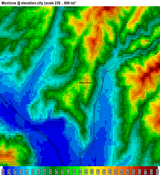
Below is the Elevation map of Montone, which displays elevation range with different colors. Scale of the first map is from 239 to 609 m (784 to 1998 ft) with average elevation of 354.8 meters (=1164 ft) [note 1]
These maps also provides idea of topography and contour of this city, they are displayed at different zoom levels. More info about maps, scale and edge coordinates you can find below images.
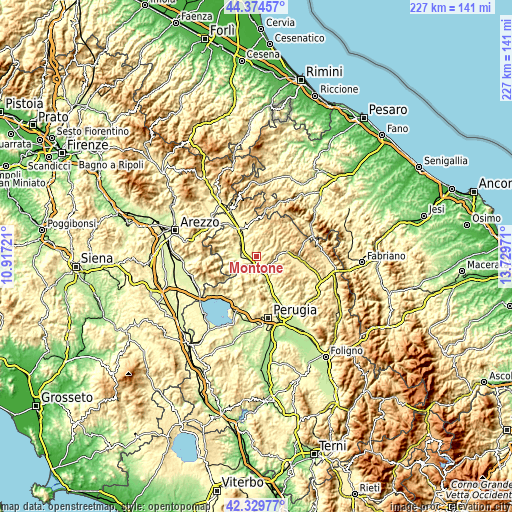
| \ | Map #1 | Topo.Map |
| Scale [m] | 239..609 m | × |
| Scale [ft] | 784..1998 ft | × |
| Average | 354.8 m = 1164 ft | × |
| Width | 7.11 km = 4.4 mi | 227.4 km = 141.3 mi |
| Height | 7.11 km = 4.4 mi | 227.4 km = 141.3 mi |
| ↑Max Latitude | 43.392722° | 44.37457° |
| Latitude at center | 43.36078° | 43.36078° |
| ↓Min Latitude | 43.328821° | 42.32977° |
| ← Min Longitude | 12.279515° | 10.91721° |
| Longitude center | 12.32346° | 12.32346° |
| →Max Longitude | 12.367405° | 13.72971° |
Nearby cities:
Cities around Montone sort by population:
• Città di Castello elevation 281 m
13.6 km,  329°
329°
• Gubbio 487 m
20.2 km,  93°
93°
• Umbertide 246 m
6.5 km,  169°
169°
• Selci-Lama 322 m
19.5 km, 332°
• Semonte-Casamorcia 439 m
16.8 km, 87°
• Cerbara 298 m
17.9 km, 329°
• Trestina 262 m
7 km,  274°
274°
• Pietralunga 548 m
12 km,  45°
45°
• San Secondo 267 m
8.7 km,  303°
303°
• Monte Grimano 751 m
16.5 km,  44°
44°
• Lisciano Niccone 314 m
19.3 km,  229°
229°
• Monte Santa Maria Tiberina 660 m
15.5 km, 303°
Multilingual:
 En español:
Montone elevación 429 m.
 En France:
Montone élévation 429 m.


Sources and notes:
- [note 1] Map square and city borders are not equal. Map elevation data is calculated only from area inside that square.
- [src 1] Elevation data from geonames database provided with same terms of usage.
- [src 2] The elevation map of Montone is generated using elevation data from NASA's 3 arcsec (90m) resolution SRTM data.
- [src 3] Base (background) map © OpenStreetMap contributors tiles are generated by Geofabrik and OpenTopoMap.
Copyright & License:
This Montone Elevation Map is licensed under CC BY-SA. You may reuse any part from this page, if you give a proper credit by linking to this URL:
 More info on terms of use page.