Cascinette d'Ivrea elevation
Cascinette d'Ivrea (Piedmont, Torino), Italy elevation is 244 meters and Cascinette d'Ivrea elevation in feet is 801 ft above sea level [src 1]. Cascinette d'Ivrea is a seat of a third-order administrative division (feature code) with elevation that is 78 meters (256 ft) smaller than average city elevation in Italy.
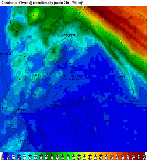
Below is the Elevation map of Cascinette d'Ivrea, which displays elevation range with different colors. Scale of the first map is from 219 to 741 m (719 to 2431 ft) with average elevation of 313.5 meters (=1029 ft) [note 1]
These maps also provides idea of topography and contour of this city, they are displayed at different zoom levels. More info about maps, scale and edge coordinates you can find below images.
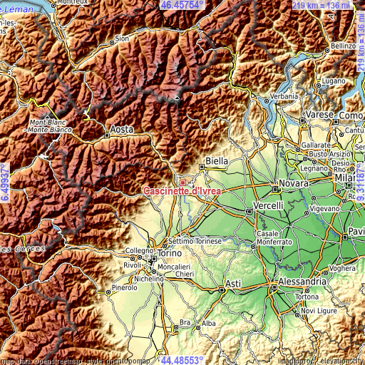
| \ | Map #1 | Topo.Map |
| Scale [m] | 219..741 m | × |
| Scale [ft] | 719..2431 ft | × |
| Average | 313.5 m = 1029 ft | × |
| Width | 6.85 km = 4.3 mi | 219.3 km = 136.3 mi |
| Height | 6.85 km = 4.3 mi | 219.3 km = 136.3 mi |
| ↑Max Latitude | 45.510964° | 46.45754° |
| Latitude at center | 45.48016° | 45.48016° |
| ↓Min Latitude | 45.449339° | 44.48553° |
| ← Min Longitude | 7.861675° | 6.49937° |
| Longitude center | 7.90562° | 7.90562° |
| →Max Longitude | 7.949565° | 9.31187° |
Nearby cities:
Cities around Cascinette d'Ivrea sort by population:
• Ivrea elevation 265 m
2.7 km,  237°
237°
• Montalto Dora 250 m
3.5 km,  287°
287°
• Banchette 254 m
4.9 km,  232°
232°
• Borgofranco d'Ivrea 256 m
5.4 km,  317°
317°
• Chiaverano 316 m
2.1 km,  353°
353°
• Bollengo 252 m
2.9 km,  108°
108°
• Burolo 277 m
2.2 km,  87°
87°
• Salerano Canavese 249 m
4.9 km, 239°
• Sala Biellese 611 m
5.2 km,  52°
52°
• Andrate 788 m
5.5 km,  339°
339°
• Donato 690 m
5.1 km,  3°
3°
• Torrazzo 620 m
4.3 km,  61°
61°
Multilingual:
 En español:
Cascinette d'Ivrea elevación 244 m.
 En France:
Cascinette d'Ivrea élévation 244 m.
 Auf Deutsch:
Cascinette d'Ivrea höhe über dem Meeresspiegel ist 244 m.
 На русском:
Cascinette d'Ivrea высота над уровнем моря 244 м
Sources and notes:
- [note 1] Map square and city borders are not equal. Map elevation data is calculated only from area inside that square.
- [src 1] Elevation data from geonames database provided with same terms of usage.
- [src 2] The elevation map of Cascinette d'Ivrea is generated using elevation data from NASA's 3 arcsec (90m) resolution SRTM data.
- [src 3] Base (background) map © OpenStreetMap contributors tiles are generated by Geofabrik and OpenTopoMap.
Copyright & License:
This Cascinette d'Ivrea Elevation Map is licensed under CC BY-SA. You may reuse any part from this page, if you give a proper credit by linking to this URL:
 More info on terms of use page.