Ivrea elevation
Ivrea (Piedmont, Torino), Italy elevation is 265 meters and Ivrea elevation in feet is 869 ft above sea level [src 1]. Ivrea is a seat of a third-order administrative division (feature code) with elevation that is 57 meters (187 ft) smaller than average city elevation in Italy.
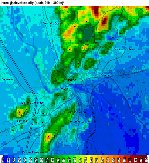
Below is the Elevation map of Ivrea, which displays elevation range with different colors. Scale of the first map is from 219 to 390 m (719 to 1280 ft) with average elevation of 251.8 meters (=826 ft) [note 1]
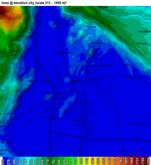
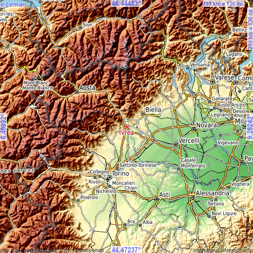
These maps also provides idea of topography and contour of this city, they are displayed at different zoom levels. More info about maps, scale and edge coordinates you can find below images.
| \ | Map #1 | Map #2 | Topo.Map |
| Scale [m] | 219..390 m | 213..1858 m | × |
| Scale [ft] | 719..1280 ft | 699..6096 ft | × |
| Average | 251.8 m = 826 ft | 362.6 m = 1190 ft | × |
| Width | 6.85 km = 4.3 mi | 13.71 km = 8.5 mi | 219.3 km = 136.3 mi |
| Height | 6.85 km = 4.3 mi | 13.71 km = 8.5 mi | 219.3 km = 136.3 mi |
| ↑Max Latitude | 45.498041° | 45.528835° | 46.44483° |
| Latitude at center | 45.46723° | 45.46723° | 45.46723° |
| ↓Min Latitude | 45.436402° | 45.405557° | 44.47237° |
| ← Min Longitude | 7.832225° | 7.788279° | 6.46992° |
| Longitude center | 7.87617° | 7.87617° | 7.87617° |
| →Max Longitude | 7.920115° | 7.964061° | 9.28242° |
Nearby cities:
Cities around Ivrea sort by population:
• Montalto Dora elevation 250 m
2.7 km,  337°
337°
• Pavone Canavese 243 m
3.3 km,  212°
212°
• Banchette 254 m
2.2 km,  225°
225°
• Samone 246 m
3.3 km, 232°
• Cascinette d'Ivrea 244 m
2.7 km,  57°
57°
• Lessolo 285 m
4.9 km,  284°
284°
• Chiaverano 316 m
4.1 km,  30°
30°
• Bollengo 252 m
5.1 km,  84°
84°
• Burolo 277 m
4.8 km,  71°
71°
• Fiorano Canavese 246 m
3.3 km,  271°
271°
• Loranzè 244 m
5.6 km,  240°
240°
• Salerano Canavese 249 m
2.2 km, 242°
Multilingual:
 En español:
Ivrea elevación 265 m.
 En France:
Ivrée élévation 265 m.


Sources and notes:
- [note 1] Map square and city borders are not equal. Map elevation data is calculated only from area inside that square.
- [src 1] Elevation data from geonames database provided with same terms of usage.
- [src 2] The elevation map of Ivrea is generated using elevation data from NASA's 3 arcsec (90m) resolution SRTM data.
- [src 3] Base (background) map © OpenStreetMap contributors tiles are generated by Geofabrik and OpenTopoMap.
Copyright & License:
This Ivrea Elevation Map is licensed under CC BY-SA. You may reuse any part from this page, if you give a proper credit by linking to this URL:
 More info on terms of use page.