Certaldo elevation
Certaldo (Tuscany, Province of Florence), Italy elevation is 71 meters and Certaldo elevation in feet is 233 ft above sea level [src 1]. Certaldo is a seat of a third-order administrative division (feature code) with elevation that is 251 meters (823 ft) smaller than average city elevation in Italy.
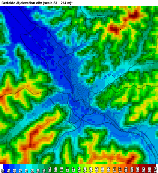
Below is the Elevation map of Certaldo, which displays elevation range with different colors. Scale of the first map is from 53 to 214 m (174 to 702 ft) with average elevation of 102.6 meters (=337 ft) [note 1]
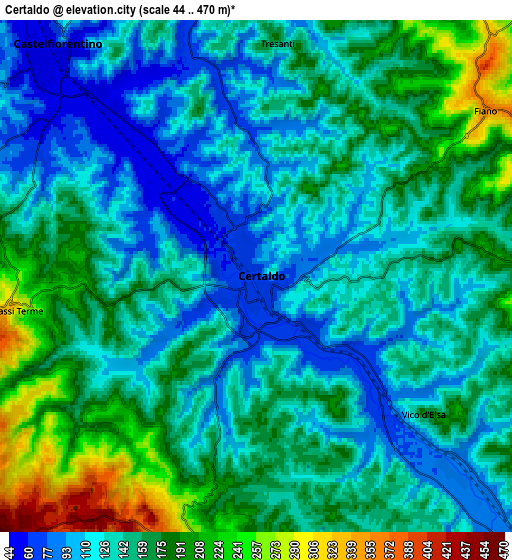
These maps also provides idea of topography and contour of this city, they are displayed at different zoom levels. More info about maps, scale and edge coordinates you can find below images.
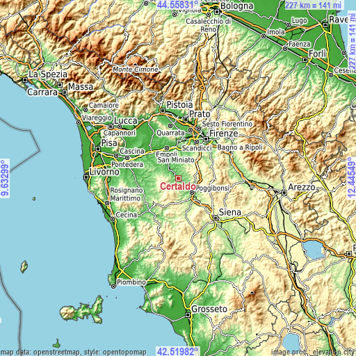
| \ | Map #1 | Map #2 | Topo.Map |
| Scale [m] | 53..214 m | 44..470 m | × |
| Scale [ft] | 174..702 ft | 144..1542 ft | × |
| Average | 102.6 m = 337 ft | 148.3 m = 487 ft | × |
| Width | 7.08 km = 4.4 mi | 14.17 km = 8.8 mi | 226.7 km = 140.9 mi |
| Height | 7.08 km = 4.4 mi | 14.17 km = 8.8 mi | 226.6 km = 140.8 mi |
| ↑Max Latitude | 43.579523° | 43.61135° | 44.55831° |
| Latitude at center | 43.54768° | 43.54768° | 43.54768° |
| ↓Min Latitude | 43.51582° | 43.483943° | 42.51982° |
| ← Min Longitude | 10.995295° | 10.951349° | 9.63299° |
| Longitude center | 11.03924° | 11.03924° | 11.03924° |
| →Max Longitude | 11.083185° | 11.127131° | 12.44549° |
Nearby cities:
Cities around Certaldo sort by population:
• Poggibonsi elevation 100 m
12.3 km,  134°
134°
• Colle di Val d'Elsa 149 m
15.8 km,  153°
153°
• Castelfiorentino 55 m
9 km,  320°
320°
• Tavarnelle Val di Pesa 366 m
10.8 km,  81°
81°
• Montespertoli 237 m
10.9 km,  14°
14°
• San Gimignano 264 m
8.3 km,  185°
185°
• Montaione 335 m
10.1 km,  272°
272°
• Gambassi Terme 359 m
7.2 km,  259°
259°
• Cerbaia 85 m
16.9 km,  25°
25°
• Bellavista 140 m
15.3 km,  140°
140°
• Barberino Val d'Elsa 341 m
10.7 km,  94°
94°
• Sambuca 177 m
14.4 km, 78°
Multilingual:
 En español:
Certaldo elevación 71 m.
 En France:
Certaldo élévation 71 m.


Sources and notes:
- [note 1] Map square and city borders are not equal. Map elevation data is calculated only from area inside that square.
- [src 1] Elevation data from geonames database provided with same terms of usage.
- [src 2] The elevation map of Certaldo is generated using elevation data from NASA's 3 arcsec (90m) resolution SRTM data.
- [src 3] Base (background) map © OpenStreetMap contributors tiles are generated by Geofabrik and OpenTopoMap.
Copyright & License:
This Certaldo Elevation Map is licensed under CC BY-SA. You may reuse any part from this page, if you give a proper credit by linking to this URL:
 More info on terms of use page.