Cerbaia elevation
Cerbaia (Tuscany, Province of Florence), Italy elevation is 85 meters and Cerbaia elevation in feet is 279 ft above sea level [src 1]. Cerbaia is a populated place (feature code) with elevation that is 237 meters (778 ft) smaller than average city elevation in Italy.
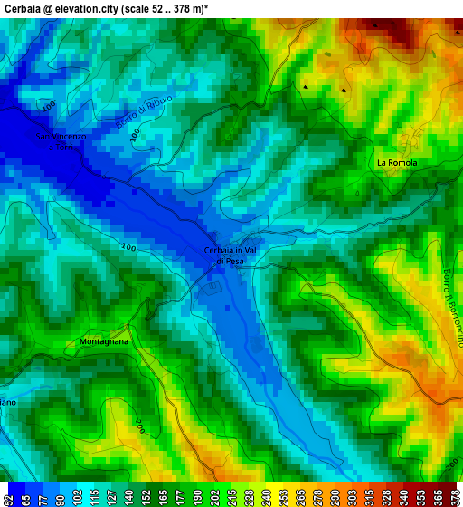
Below is the Elevation map of Cerbaia, which displays elevation range with different colors. Scale of the first map is from 52 to 378 m (171 to 1240 ft) with average elevation of 159.4 meters (=523 ft) [note 1]
These maps also provides idea of topography and contour of this city, they are displayed at different zoom levels. More info about maps, scale and edge coordinates you can find below images.

| \ | Map #1 | Topo.Map |
| Scale [m] | 52..378 m | × |
| Scale [ft] | 171..1240 ft | × |
| Average | 159.4 m = 523 ft | × |
| Width | 7.07 km = 4.4 mi | 226.1 km = 140.5 mi |
| Height | 7.07 km = 4.4 mi | 226.1 km = 140.5 mi |
| ↑Max Latitude | 43.71696° | 44.69349° |
| Latitude at center | 43.68519° | 43.68519° |
| ↓Min Latitude | 43.653403° | 42.65965° |
| ← Min Longitude | 11.084945° | 9.72264° |
| Longitude center | 11.12889° | 11.12889° |
| →Max Longitude | 11.172835° | 12.53514° |
Nearby cities:
Cities around Cerbaia sort by population:
• Scandicci elevation 46 m
9 km,  31°
31°
• Lastra a Signa 37 m
9.5 km,  352°
352°
• Montelupo Fiorentino 39 m
10.8 km,  297°
297°
• San Casciano in Val di Pesa 299 m
5.3 km,  122°
122°
• Impruneta 261 m
10.1 km,  90°
90°
• Tavarnuzze 75 m
7.6 km,  68°
68°
• Montespertoli 237 m
6.5 km,  223°
223°
• Mantignano-Ugnano 38 m
11.2 km,  16°
16°
• Mercatale 291 m
9.6 km, 124°
• Ginestra Fiorentina 72 m
5.2 km, 301°
• Malmantile 199 m
8.2 km,  326°
326°
• Quattro Strade 154 m
7.4 km, 328°
Multilingual:
 En español:
Cerbaia elevación 85 m.
 En France:
Cerbaia élévation 85 m.


Sources and notes:
- [note 1] Map square and city borders are not equal. Map elevation data is calculated only from area inside that square.
- [src 1] Elevation data from geonames database provided with same terms of usage.
- [src 2] The elevation map of Cerbaia is generated using elevation data from NASA's 3 arcsec (90m) resolution SRTM data.
- [src 3] Base (background) map © OpenStreetMap contributors tiles are generated by Geofabrik and OpenTopoMap.
Copyright & License:
This Cerbaia Elevation Map is licensed under CC BY-SA. You may reuse any part from this page, if you give a proper credit by linking to this URL:
 More info on terms of use page.