Scandicci elevation
Scandicci (Tuscany, Province of Florence), Italy elevation is 46 meters and Scandicci elevation in feet is 151 ft above sea level [src 1]. Scandicci is a seat of a third-order administrative division (feature code) with elevation that is 276 meters (906 ft) smaller than average city elevation in Italy.
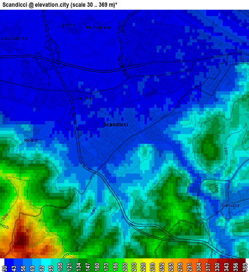
Below is the Elevation map of Scandicci, which displays elevation range with different colors. Scale of the first map is from 30 to 369 m (98 to 1211 ft) with average elevation of 82.7 meters (=271 ft) [note 1]
These maps also provides idea of topography and contour of this city, they are displayed at different zoom levels. More info about maps, scale and edge coordinates you can find below images.
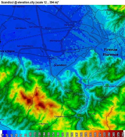
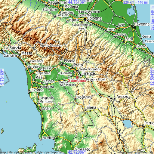
| \ | Map #1 | Map #2 | Topo.Map |
| Scale [m] | 30..369 m | 12..394 m | × |
| Scale [ft] | 98..1211 ft | 39..1293 ft | × |
| Average | 82.7 m = 271 ft | 106.1 m = 348 ft | × |
| Width | 7.06 km = 4.4 mi | 14.12 km = 8.8 mi | 225.9 km = 140.4 mi |
| Height | 7.06 km = 4.4 mi | 14.12 km = 8.8 mi | 225.9 km = 140.4 mi |
| ↑Max Latitude | 43.785964° | 43.817681° | 44.76136° |
| Latitude at center | 43.75423° | 43.75423° | 43.75423° |
| ↓Min Latitude | 43.722479° | 43.690712° | 42.72986° |
| ← Min Longitude | 11.143995° | 11.100049° | 9.78169° |
| Longitude center | 11.18794° | 11.18794° | 11.18794° |
| →Max Longitude | 11.231885° | 11.275831° | 12.59419° |
Nearby cities:
Cities around Scandicci sort by population:
• Florence elevation 51 m
5.4 km,  59°
59°
• Sesto Fiorentino 60 m
8.7 km,  5°
5°
• Campi Bisenzio 38 m
9.1 km,  329°
329°
• Signa 34 m
8.1 km,  303°
303°
• Lastra a Signa 37 m
6.3 km,  286°
286°
• Grassina Ponte a Ema 87 m
9.3 km,  104°
104°
• San Donnino 37 m
5.7 km,  324°
324°
• Tavarnuzze 75 m
5.4 km,  154°
154°
• San Mauro 37 m
6.7 km,  311°
311°
• Mantignano-Ugnano 38 m
3.4 km, 334°
• Cerbaia 85 m
9 km,  211°
211°
• Quattro Strade 154 m
8.7 km,  260°
260°
Multilingual:
 En español:
Scandicci elevación 46 m.
 En France:
Scandicci élévation 46 m.
 Auf Deutsch:
Scandicci höhe über dem Meeresspiegel ist 46 m.

Sources and notes:
- [note 1] Map square and city borders are not equal. Map elevation data is calculated only from area inside that square.
- [src 1] Elevation data from geonames database provided with same terms of usage.
- [src 2] The elevation map of Scandicci is generated using elevation data from NASA's 3 arcsec (90m) resolution SRTM data.
- [src 3] Base (background) map © OpenStreetMap contributors tiles are generated by Geofabrik and OpenTopoMap.
Copyright & License:
This Scandicci Elevation Map is licensed under CC BY-SA. You may reuse any part from this page, if you give a proper credit by linking to this URL:
 More info on terms of use page.