Signa elevation
Signa (Tuscany, Province of Florence), Italy elevation is 34 meters and Signa elevation in feet is 112 ft above sea level [src 1]. Signa is a seat of a third-order administrative division (feature code) with elevation that is 288 meters (945 ft) smaller than average city elevation in Italy.
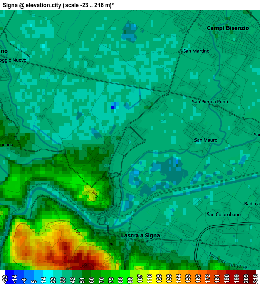
Below is the Elevation map of Signa, which displays elevation range with different colors. Scale of the first map is from -23 to 218 m (-75 to 715 ft) with average elevation of 45.8 meters (=150 ft) [note 1]
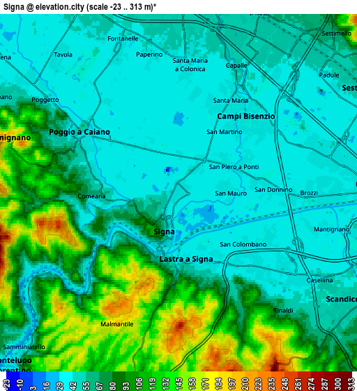
These maps also provides idea of topography and contour of this city, they are displayed at different zoom levels. More info about maps, scale and edge coordinates you can find below images.
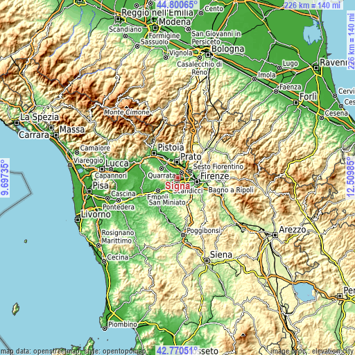
| \ | Map #1 | Map #2 | Topo.Map |
| Scale [m] | -23..218 m | -23..313 m | × |
| Scale [ft] | -75..715 ft | -75..1027 ft | × |
| Average | 45.8 m = 150 ft | 71.6 m = 235 ft | × |
| Width | 7.05 km = 4.4 mi | 14.11 km = 8.8 mi | 225.7 km = 140.2 mi |
| Height | 7.05 km = 4.4 mi | 14.11 km = 8.8 mi | 225.7 km = 140.2 mi |
| ↑Max Latitude | 43.825913° | 43.857608° | 44.80065° |
| Latitude at center | 43.7942° | 43.7942° | 43.7942° |
| ↓Min Latitude | 43.762471° | 43.730724° | 42.77051° |
| ← Min Longitude | 11.059655° | 11.015709° | 9.69735° |
| Longitude center | 11.1036° | 11.1036° | 11.1036° |
| →Max Longitude | 11.147545° | 11.191491° | 12.50985° |
Nearby cities:
Cities around Signa sort by population:
• Campi Bisenzio elevation 38 m
4 km,  32°
32°
• Lastra a Signa 37 m
2.8 km,  164°
164°
• Poggio A Caiano 42 m
4.7 km,  297°
297°
• Seano 46 m
7.7 km, 301°
• San Donnino 37 m
3.4 km,  87°
87°
• San Mauro 37 m
1.7 km, 90°
• Mantignano-Ugnano 38 m
5.5 km,  104°
104°
• Comeana 67 m
3.6 km,  268°
268°
• Carmignano 203 m
7.3 km,  284°
284°
• Poggetto 42 m
6.4 km,  305°
305°
• Malmantile 199 m
5.8 km,  205°
205°
• Quattro Strade 154 m
6.1 km,  197°
197°
Multilingual:
 En español:
Signa elevación 34 m.
 En France:
Signa élévation 34 m.


Sources and notes:
- [note 1] Map square and city borders are not equal. Map elevation data is calculated only from area inside that square.
- [src 1] Elevation data from geonames database provided with same terms of usage.
- [src 2] The elevation map of Signa is generated using elevation data from NASA's 3 arcsec (90m) resolution SRTM data.
- [src 3] Base (background) map © OpenStreetMap contributors tiles are generated by Geofabrik and OpenTopoMap.
Copyright & License:
This Signa Elevation Map is licensed under CC BY-SA. You may reuse any part from this page, if you give a proper credit by linking to this URL:
 More info on terms of use page.