Crone elevation
Crone (Lombardy, Provincia di Brescia), Italy elevation is 375 meters and Crone elevation in feet is 1230 ft above sea level [src 1]. Crone is a seat of a third-order administrative division (feature code) with elevation that is 53 meters (174 ft) bigger than average city elevation in Italy.
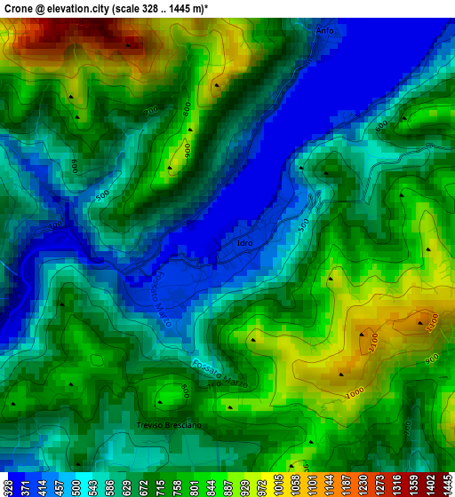
Below is the Elevation map of Crone, which displays elevation range with different colors. Scale of the first map is from 328 to 1445 m (1076 to 4741 ft) with average elevation of 681.2 meters (=2235 ft) [note 1]
These maps also provides idea of topography and contour of this city, they are displayed at different zoom levels. More info about maps, scale and edge coordinates you can find below images.
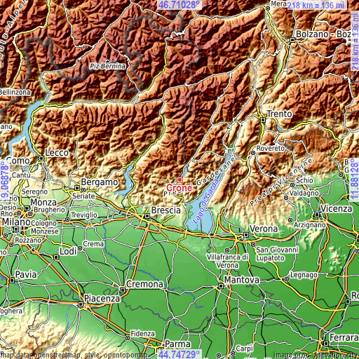
| \ | Map #1 | Topo.Map |
| Scale [m] | 328..1445 m | × |
| Scale [ft] | 1076..4741 ft | × |
| Average | 681.2 m = 2235 ft | × |
| Width | 6.82 km = 4.2 mi | 218.3 km = 135.6 mi |
| Height | 6.82 km = 4.2 mi | 218.3 km = 135.6 mi |
| ↑Max Latitude | 45.768073° | 46.71028° |
| Latitude at center | 45.73741° | 45.73741° |
| ↓Min Latitude | 45.70673° | 44.74729° |
| ← Min Longitude | 10.431085° | 9.06878° |
| Longitude center | 10.47503° | 10.47503° |
| →Max Longitude | 10.518975° | 11.88128° |
Nearby cities:
Cities around Crone sort by population:
• Vestone elevation 352 m
7 km,  241°
241°
• Idro 375 m
0.2 km,  221°
221°
• Provaglio Val Sabbia 659 m
6.3 km,  210°
210°
• Barghe 293 m
8.4 km, 218°
• Pertica Bassa 513 m
8.2 km,  282°
282°
• Lavenone 367 m
2.8 km,  272°
272°
• Anfo 381 m
3.5 km,  24°
24°
• Trebbio 682 m
2.9 km,  201°
201°
• Valvestino 658 m
9.7 km,  74°
74°
• Capovalle 902 m
5.7 km, 71°
• Cedessano 658 m
6.3 km, 210°
• Bondone 732 m
9.6 km,  37°
37°
Multilingual:
 En español:
Crone elevación 375 m.
 En France:
Crone élévation 375 m.


Sources and notes:
- [note 1] Map square and city borders are not equal. Map elevation data is calculated only from area inside that square.
- [src 1] Elevation data from geonames database provided with same terms of usage.
- [src 2] The elevation map of Crone is generated using elevation data from NASA's 3 arcsec (90m) resolution SRTM data.
- [src 3] Base (background) map © OpenStreetMap contributors tiles are generated by Geofabrik and OpenTopoMap.
Copyright & License:
This Crone Elevation Map is licensed under CC BY-SA. You may reuse any part from this page, if you give a proper credit by linking to this URL:
 More info on terms of use page.