Barghe elevation
Barghe (Lombardy, Provincia di Brescia), Italy elevation is 293 meters and Barghe elevation in feet is 961 ft above sea level [src 1]. Barghe is a seat of a third-order administrative division (feature code) with elevation that is 29 meters (95 ft) smaller than average city elevation in Italy.
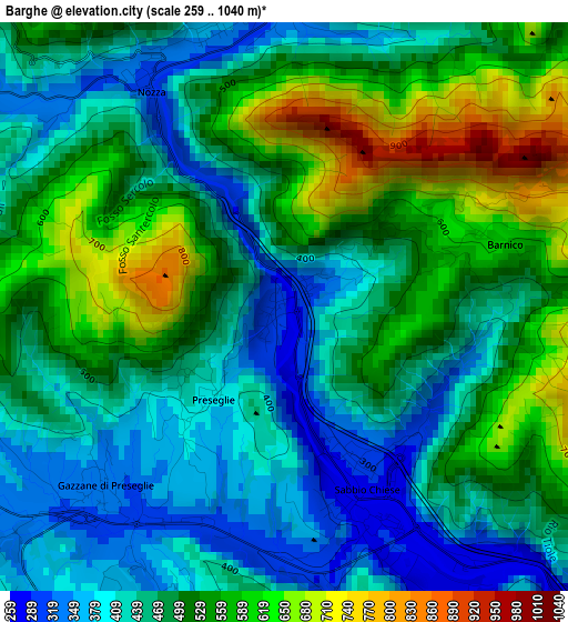
Below is the Elevation map of Barghe, which displays elevation range with different colors. Scale of the first map is from 259 to 1040 m (850 to 3412 ft) with average elevation of 489.3 meters (=1605 ft) [note 1]
These maps also provides idea of topography and contour of this city, they are displayed at different zoom levels. More info about maps, scale and edge coordinates you can find below images.
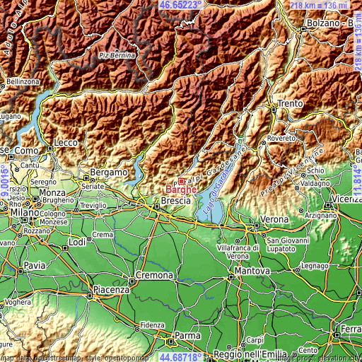
| \ | Map #1 | Topo.Map |
| Scale [m] | 259..1040 m | × |
| Scale [ft] | 850..3412 ft | × |
| Average | 489.3 m = 1605 ft | × |
| Width | 6.83 km = 4.2 mi | 218.5 km = 135.8 mi |
| Height | 6.83 km = 4.2 mi | 218.5 km = 135.8 mi |
| ↑Max Latitude | 45.709026° | 46.65223° |
| Latitude at center | 45.67833° | 45.67833° |
| ↓Min Latitude | 45.647618° | 44.68718° |
| ← Min Longitude | 10.363805° | 9.0015° |
| Longitude center | 10.40775° | 10.40775° |
| →Max Longitude | 10.451695° | 11.814° |
Nearby cities:
Cities around Barghe sort by population:
• Vestone elevation 352 m
3.4 km,  344°
344°
• Sabbio Chiese 278 m
2.7 km,  156°
156°
• Odolo 370 m
4.1 km,  207°
207°
• Preseglie 394 m
1.4 km,  217°
217°
• Bione 609 m
5.4 km,  263°
263°
• Agnosine 470 m
5.3 km,  233°
233°
• Provaglio Val Sabbia 659 m
2.3 km,  60°
60°
• Sottocastello 401 m
1.6 km, 220°
• Casto 425 m
7 km,  285°
285°
• Mura 696 m
6.4 km,  307°
307°
• Trebbio 682 m
5.7 km,  47°
47°
• Cedessano 658 m
2.3 km, 60°
Multilingual:
 En español:
Barghe elevación 293 m.
 En France:
Barghe élévation 293 m.


Sources and notes:
- [note 1] Map square and city borders are not equal. Map elevation data is calculated only from area inside that square.
- [src 1] Elevation data from geonames database provided with same terms of usage.
- [src 2] The elevation map of Barghe is generated using elevation data from NASA's 3 arcsec (90m) resolution SRTM data.
- [src 3] Base (background) map © OpenStreetMap contributors tiles are generated by Geofabrik and OpenTopoMap.
Copyright & License:
This Barghe Elevation Map is licensed under CC BY-SA. You may reuse any part from this page, if you give a proper credit by linking to this URL:
 More info on terms of use page.