Pertica Bassa elevation
Pertica Bassa (Lombardy, Provincia di Brescia), Italy elevation is 513 meters and Pertica Bassa elevation in feet is 1683 ft above sea level [src 1]. Pertica Bassa is a seat of a third-order administrative division (feature code) with elevation that is 191 meters (627 ft) bigger than average city elevation in Italy.
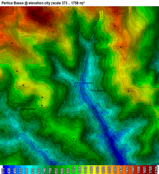
Below is the Elevation map of Pertica Bassa, which displays elevation range with different colors. Scale of the first map is from 373 to 1758 m (1224 to 5768 ft) with average elevation of 947.4 meters (=3108 ft) [note 1]
These maps also provides idea of topography and contour of this city, they are displayed at different zoom levels. More info about maps, scale and edge coordinates you can find below images.
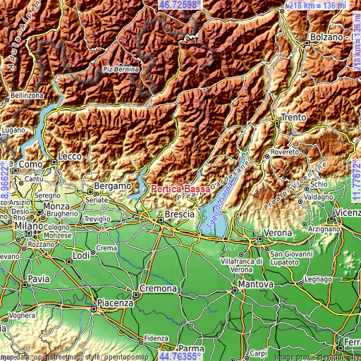
| \ | Map #1 | Topo.Map |
| Scale [m] | 373..1758 m | × |
| Scale [ft] | 1224..5768 ft | × |
| Average | 947.4 m = 3108 ft | × |
| Width | 6.82 km = 4.2 mi | 218.2 km = 135.6 mi |
| Height | 6.82 km = 4.2 mi | 218.2 km = 135.6 mi |
| ↑Max Latitude | 45.784044° | 46.72598° |
| Latitude at center | 45.75339° | 45.75339° |
| ↓Min Latitude | 45.722719° | 44.76355° |
| ← Min Longitude | 10.328525° | 8.96622° |
| Longitude center | 10.37247° | 10.37247° |
| →Max Longitude | 10.416415° | 11.77872° |
Nearby cities:
Cities around Pertica Bassa sort by population:
• Vestone elevation 352 m
5.4 km,  160°
160°
• Idro 375 m
8.1 km,  103°
103°
• Crone 375 m
8.2 km, 102°
• Collio 849 m
7 km,  335°
335°
• Casto 425 m
7.6 km,  211°
211°
• Marmentino 883 m
6.8 km,  271°
271°
• Pertica Alta 899 m
2.5 km,  240°
240°
• Dosso-Ville 784 m
7.6 km, 269°
• Lavenone 367 m
5.4 km,  107°
107°
• Mura 696 m
5.1 km, 207°
• Trebbio 682 m
8.2 km,  123°
123°
• Irma 814 m
7.1 km,  286°
286°
Multilingual:
 En español:
Pertica Bassa elevación 513 m.
 En France:
Pertica Bassa élévation 513 m.
 Auf Deutsch:
Pertica Bassa höhe über dem Meeresspiegel ist 513 m.

Sources and notes:
- [note 1] Map square and city borders are not equal. Map elevation data is calculated only from area inside that square.
- [src 1] Elevation data from geonames database provided with same terms of usage.
- [src 2] The elevation map of Pertica Bassa is generated using elevation data from NASA's 3 arcsec (90m) resolution SRTM data.
- [src 3] Base (background) map © OpenStreetMap contributors tiles are generated by Geofabrik and OpenTopoMap.
Copyright & License:
This Pertica Bassa Elevation Map is licensed under CC BY-SA. You may reuse any part from this page, if you give a proper credit by linking to this URL:
 More info on terms of use page.