Bondone elevation
Bondone (Trentino-Alto Adige, Provincia autonoma di Trento), Italy elevation is 732 meters and Bondone elevation in feet is 2402 ft above sea level [src 1]. Bondone is a seat of a third-order administrative division (feature code) with elevation that is 410 meters (1345 ft) bigger than average city elevation in Italy.
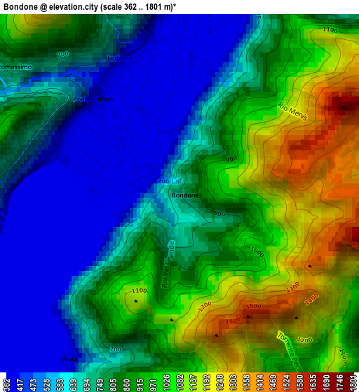
Below is the Elevation map of Bondone, which displays elevation range with different colors. Scale of the first map is from 362 to 1801 m (1188 to 5909 ft) with average elevation of 818.7 meters (=2686 ft) [note 1]
These maps also provides idea of topography and contour of this city, they are displayed at different zoom levels. More info about maps, scale and edge coordinates you can find below images.
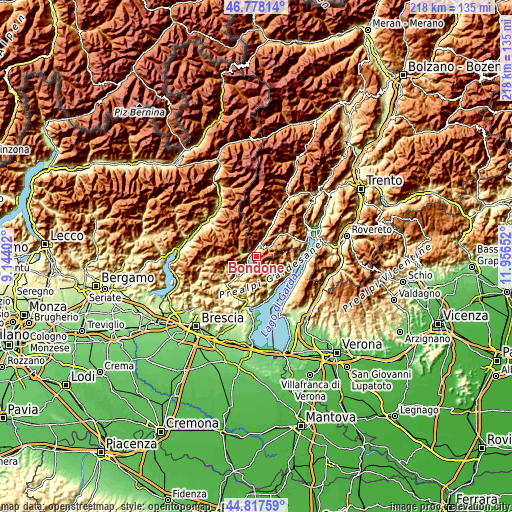
| \ | Map #1 | Topo.Map |
| Scale [m] | 362..1801 m | × |
| Scale [ft] | 1188..5909 ft | × |
| Average | 818.7 m = 2686 ft | × |
| Width | 6.81 km = 4.2 mi | 218 km = 135.5 mi |
| Height | 6.81 km = 4.2 mi | 218 km = 135.5 mi |
| ↑Max Latitude | 45.837115° | 46.77814° |
| Latitude at center | 45.80649° | 45.80649° |
| ↓Min Latitude | 45.775848° | 44.81759° |
| ← Min Longitude | 10.506325° | 9.14402° |
| Longitude center | 10.55027° | 10.55027° |
| →Max Longitude | 10.594215° | 11.95652° |
Nearby cities:
Cities around Bondone sort by population:
• Storo elevation 395 m
5.3 km,  26°
26°
• Bagolino 755 m
7.2 km,  286°
286°
• Lodrone-Darzo 401 m
2.8 km,  336°
336°
• Idro 375 m
9.8 km,  217°
217°
• Crone 375 m
9.6 km, 217°
• Condino 423 m
9 km,  21°
21°
• Ponte Caffaro 378 m
2.4 km,  311°
311°
• Anfo 381 m
6.3 km, 224°
• Valvestino 658 m
6.2 km,  145°
145°
• Capovalle 902 m
5.9 km,  184°
184°
• Magasa 1006 m
5.8 km,  118°
118°
• Brione 907 m
10.3 km, 17°
Multilingual:
 En español:
Bondone elevación 732 m.
 En France:
Bondone élévation 732 m.


Sources and notes:
- [note 1] Map square and city borders are not equal. Map elevation data is calculated only from area inside that square.
- [src 1] Elevation data from geonames database provided with same terms of usage.
- [src 2] The elevation map of Bondone is generated using elevation data from NASA's 3 arcsec (90m) resolution SRTM data.
- [src 3] Base (background) map © OpenStreetMap contributors tiles are generated by Geofabrik and OpenTopoMap.
Copyright & License:
This Bondone Elevation Map is licensed under CC BY-SA. You may reuse any part from this page, if you give a proper credit by linking to this URL:
 More info on terms of use page.