Gallese elevation
Gallese (Latium, Provincia di Viterbo), Italy elevation is 149 meters and Gallese elevation in feet is 489 ft above sea level [src 1]. Gallese is a seat of a third-order administrative division (feature code) with elevation that is 173 meters (568 ft) smaller than average city elevation in Italy.
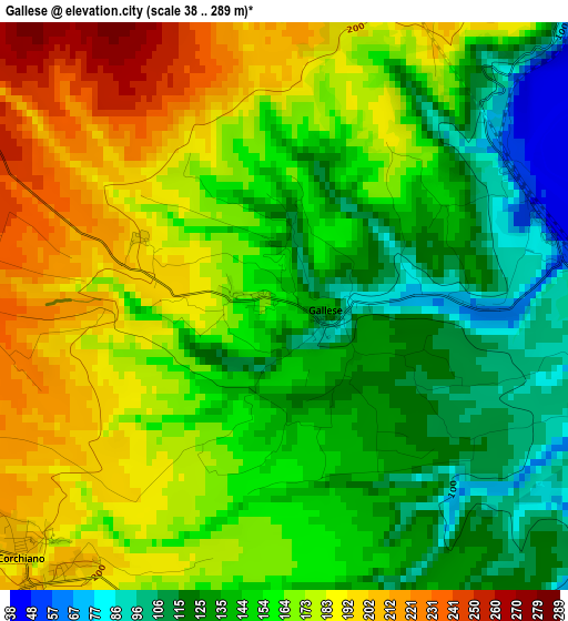
Below is the Elevation map of Gallese, which displays elevation range with different colors. Scale of the first map is from 38 to 289 m (125 to 948 ft) with average elevation of 158.3 meters (=519 ft) [note 1]
These maps also provides idea of topography and contour of this city, they are displayed at different zoom levels. More info about maps, scale and edge coordinates you can find below images.
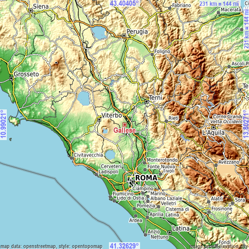
| \ | Map #1 | Topo.Map |
| Scale [m] | 38..289 m | × |
| Scale [ft] | 125..948 ft | × |
| Average | 158.3 m = 519 ft | × |
| Width | 7.22 km = 4.5 mi | 231 km = 143.5 mi |
| Height | 7.22 km = 4.5 mi | 231 km = 143.5 mi |
| ↑Max Latitude | 42.406217° | 43.40405° |
| Latitude at center | 42.37376° | 42.37376° |
| ↓Min Latitude | 42.341286° | 41.32629° |
| ← Min Longitude | 12.352515° | 10.99021° |
| Longitude center | 12.39646° | 12.39646° |
| →Max Longitude | 12.440405° | 13.80271° |
Nearby cities:
Cities around Gallese sort by population:
• Civita Castellana elevation 151 m
9 km,  173°
173°
• Fabrica di Roma 273 m
9.1 km,  241°
241°
• Vignanello 383 m
9.7 km,  273°
273°
• Vasanello 266 m
6.1 km,  318°
318°
• Orte 132 m
9.8 km,  355°
355°
• Orte Scalo 57 m
6.9 km,  7°
7°
• Corchiano 204 m
4.6 km,  225°
225°
• Vallerano 414 m
11.1 km,  275°
275°
• Magliano Sabina 178 m
7.3 km,  97°
97°
• Regolelli 199 m
9.7 km,  202°
202°
• Sassacci 122 m
6.7 km,  146°
146°
• Otricoli 191 m
8.5 km,  51°
51°
Multilingual:
 En español:
Gallese elevación 149 m.
 En France:
Gallese élévation 149 m.


Sources and notes:
- [note 1] Map square and city borders are not equal. Map elevation data is calculated only from area inside that square.
- [src 1] Elevation data from geonames database provided with same terms of usage.
- [src 2] The elevation map of Gallese is generated using elevation data from NASA's 3 arcsec (90m) resolution SRTM data.
- [src 3] Base (background) map © OpenStreetMap contributors tiles are generated by Geofabrik and OpenTopoMap.
Copyright & License:
This Gallese Elevation Map is licensed under CC BY-SA. You may reuse any part from this page, if you give a proper credit by linking to this URL:
 More info on terms of use page.