Regolelli elevation
Regolelli (Latium, Provincia di Viterbo), Italy elevation is 199 meters and Regolelli elevation in feet is 653 ft above sea level [src 1]. Regolelli is a populated place (feature code) with elevation that is 123 meters (404 ft) smaller than average city elevation in Italy.
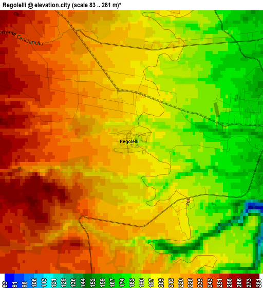
Below is the Elevation map of Regolelli, which displays elevation range with different colors. Scale of the first map is from 83 to 281 m (272 to 922 ft) with average elevation of 211.7 meters (=695 ft) [note 1]
These maps also provides idea of topography and contour of this city, they are displayed at different zoom levels. More info about maps, scale and edge coordinates you can find below images.
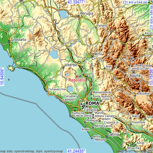
| \ | Map #1 | Topo.Map |
| Scale [m] | 83..281 m | × |
| Scale [ft] | 272..922 ft | × |
| Average | 211.7 m = 695 ft | × |
| Width | 7.23 km = 4.5 mi | 231.3 km = 143.7 mi |
| Height | 7.23 km = 4.5 mi | 231.3 km = 143.7 mi |
| ↑Max Latitude | 42.325648° | 43.32477° |
| Latitude at center | 42.29315° | 42.29315° |
| ↓Min Latitude | 42.260635° | 41.24435° |
| ← Min Longitude | 12.307365° | 10.94506° |
| Longitude center | 12.35131° | 12.35131° |
| →Max Longitude | 12.395255° | 13.75756° |
Nearby cities:
Cities around Regolelli sort by population:
• Civita Castellana elevation 151 m
4.7 km,  90°
90°
• Nepi 222 m
5.7 km,  186°
186°
• Fabrica di Roma 273 m
6.3 km,  316°
316°
• Caprarola 482 m
9.9 km,  289°
289°
• Corchiano 204 m
5.8 km,  4°
4°
• Mazzano Romano 226 m
10.4 km,  159°
159°
• Castel Sant'Elia 218 m
4.9 km, 161°
• Carbognano 396 m
8.2 km,  300°
300°
• Faleria 211 m
10.8 km,  134°
134°
• Gallese 149 m
9.7 km,  22°
22°
• Sassacci 122 m
8.1 km,  65°
65°
• Calcata Nuova 220 m
10.2 km,  143°
143°
Multilingual:
 En español:
Regolelli elevación 199 m.
 En France:
Regolelli élévation 199 m.
 Auf Deutsch:
Regolelli höhe über dem Meeresspiegel ist 199 m.

Sources and notes:
- [note 1] Map square and city borders are not equal. Map elevation data is calculated only from area inside that square.
- [src 1] Elevation data from geonames database provided with same terms of usage.
- [src 2] The elevation map of Regolelli is generated using elevation data from NASA's 3 arcsec (90m) resolution SRTM data.
- [src 3] Base (background) map © OpenStreetMap contributors tiles are generated by Geofabrik and OpenTopoMap.
Copyright & License:
This Regolelli Elevation Map is licensed under CC BY-SA. You may reuse any part from this page, if you give a proper credit by linking to this URL:
 More info on terms of use page.