Genga elevation
Genga (The Marches, Provincia di Ancona), Italy elevation is 303 meters and Genga elevation in feet is 994 ft above sea level [src 1]. Genga is a seat of a third-order administrative division (feature code) with elevation that is 19 meters (62 ft) smaller than average city elevation in Italy.
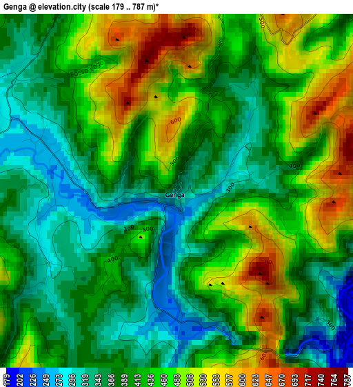
Below is the Elevation map of Genga, which displays elevation range with different colors. Scale of the first map is from 179 to 787 m (587 to 2582 ft) with average elevation of 421.3 meters (=1382 ft) [note 1]
These maps also provides idea of topography and contour of this city, they are displayed at different zoom levels. More info about maps, scale and edge coordinates you can find below images.
| \ | Map #1 | Topo.Map |
| Scale [m] | 179..787 m | × |
| Scale [ft] | 587..2582 ft | × |
| Average | 421.3 m = 1382 ft | × |
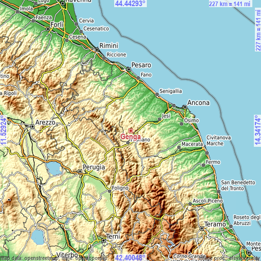
| Width | 7.1 km = 4.4 mi | 227.1 km = 141.1 mi |
| Height | 7.1 km = 4.4 mi | 227.1 km = 141.1 mi |
| ↑Max Latitude | 43.462225° | 44.44293° |
| Latitude at center | 43.43032° | 43.43032° |
| ↓Min Latitude | 43.398398° | 42.40048° |
| ← Min Longitude | 12.891545° | 11.52924° |
| Longitude center | 12.93549° | 12.93549° |
| →Max Longitude | 12.979435° | 14.34174° |
Nearby cities:
Cities around Genga sort by population:
• Fabriano elevation 315 m
10.4 km,  194°
194°
• Sassoferrato 284 m
6.4 km,  270°
270°
• Cupramontana 442 m
14.5 km,  81°
81°
• Cerreto d'Esi 288 m
13.3 km,  161°
161°
• Macine-Borgo Loreto 133 m
13.7 km,  63°
63°
• Serra San Quirico 185 m
7.3 km, 75°
• Arcevia 416 m
8 km,  5°
5°
• Castelplanio 312 m
13.8 km, 58°
• Poggio San Marcello 407 m
14.3 km,  51°
51°
• Mergo 365 m
9.4 km, 59°
• Rosora 377 m
12.2 km, 61°
• Poggio San Vicino 475 m
13.2 km,  117°
117°
Multilingual:
 En español:
Genga elevación 303 m.
 En France:
Genga élévation 303 m.


Sources and notes:
- [note 1] Map square and city borders are not equal. Map elevation data is calculated only from area inside that square.
- [src 1] Elevation data from geonames database provided with same terms of usage.
- [src 2] The elevation map of Genga is generated using elevation data from NASA's 3 arcsec (90m) resolution SRTM data.
- [src 3] Base (background) map © OpenStreetMap contributors tiles are generated by Geofabrik and OpenTopoMap.
Copyright & License:
This Genga Elevation Map is licensed under CC BY-SA. You may reuse any part from this page, if you give a proper credit by linking to this URL:
 More info on terms of use page.