Serra San Quirico elevation
Serra San Quirico (The Marches, Provincia di Ancona), Italy elevation is 185 meters and Serra San Quirico elevation in feet is 607 ft above sea level [src 1]. Serra San Quirico is a seat of a third-order administrative division (feature code) with elevation that is 137 meters (449 ft) smaller than average city elevation in Italy.
Below is the Elevation map of Serra San Quirico, which displays elevation range with different colors. Scale of the first map is from 130 to 859 m (427 to 2818 ft) with average elevation of 365.7 meters (=1200 ft) [note 1]
These maps also provides idea of topography and contour of this city, they are displayed at different zoom levels. More info about maps, scale and edge coordinates you can find below images.
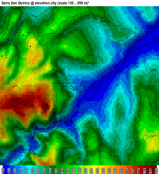
| \ | Map #1 | Topo.Map |
| Scale [m] | 130..859 m | × |
| Scale [ft] | 427..2818 ft | × |
| Average | 365.7 m = 1200 ft | × |
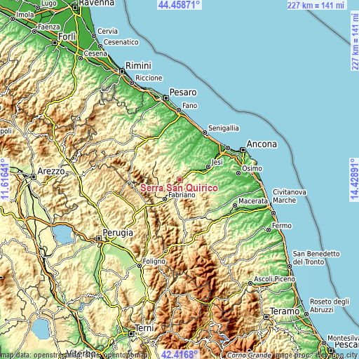
| Width | 7.09 km = 4.4 mi | 227 km = 141.1 mi |
| Height | 7.1 km = 4.4 mi | 227 km = 141.1 mi |
| ↑Max Latitude | 43.478267° | 44.45871° |
| Latitude at center | 43.44637° | 43.44637° |
| ↓Min Latitude | 43.414456° | 42.4168° |
| ← Min Longitude | 12.978715° | 11.61641° |
| Longitude center | 13.02266° | 13.02266° |
| →Max Longitude | 13.066605° | 14.42891° |
Nearby cities:
Cities around Serra San Quirico sort by population:
• Cupramontana elevation 442 m
7.3 km,  87°
87°
• Macine-Borgo Loreto 133 m
6.8 km,  49°
49°
• Montecarotto 334 m
9.8 km,  21°
21°
• Arcevia 416 m
8.8 km,  314°
314°
• Castelplanio 312 m
7.1 km,  41°
41°
• Maiolati Spontini 402 m
8.5 km,  66°
66°
• Poggio San Marcello 407 m
8.3 km,  29°
29°
• Mergo 365 m
3.2 km, 18°
• Rosora 377 m
5.5 km, 41°
• Monte Roberto 332 m
10.1 km, 67°
• Poggio San Vicino 475 m
9.2 km,  150°
150°
• Genga 303 m
7.3 km,  255°
255°
Multilingual:
 En español:
Serra San Quirico elevación 185 m.
 En France:
Serra San Quirico élévation 185 m.
 Auf Deutsch:
Serra San Quirico höhe über dem Meeresspiegel ist 185 m.

Sources and notes:
- [note 1] Map square and city borders are not equal. Map elevation data is calculated only from area inside that square.
- [src 1] Elevation data from geonames database provided with same terms of usage.
- [src 2] The elevation map of Serra San Quirico is generated using elevation data from NASA's 3 arcsec (90m) resolution SRTM data.
- [src 3] Base (background) map © OpenStreetMap contributors tiles are generated by Geofabrik and OpenTopoMap.
Copyright & License:
This Serra San Quirico Elevation Map is licensed under CC BY-SA. You may reuse any part from this page, if you give a proper credit by linking to this URL:
 More info on terms of use page.