Ghedi elevation
Ghedi (Lombardy, Provincia di Brescia), Italy elevation is 85 meters and Ghedi elevation in feet is 279 ft above sea level [src 1]. Ghedi is a seat of a third-order administrative division (feature code) with elevation that is 237 meters (778 ft) smaller than average city elevation in Italy.
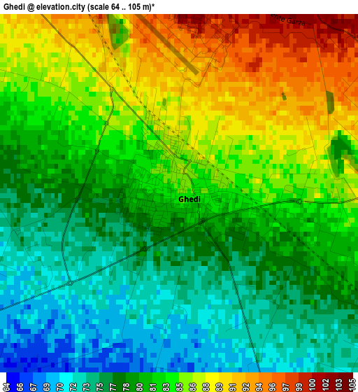
Below is the Elevation map of Ghedi, which displays elevation range with different colors. Scale of the first map is from 64 to 105 m (210 to 344 ft) with average elevation of 81.5 meters (=267 ft) [note 1]
These maps also provides idea of topography and contour of this city, they are displayed at different zoom levels. More info about maps, scale and edge coordinates you can find below images.
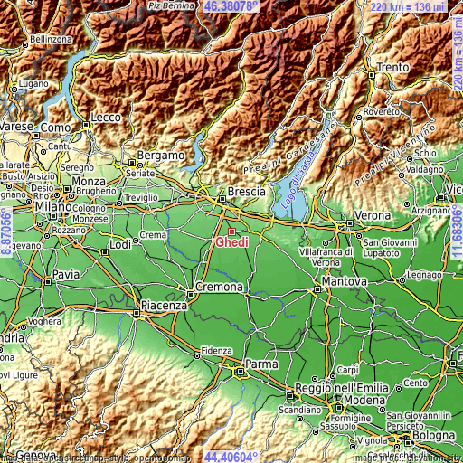
| \ | Map #1 | Map #2 | Topo.Map |
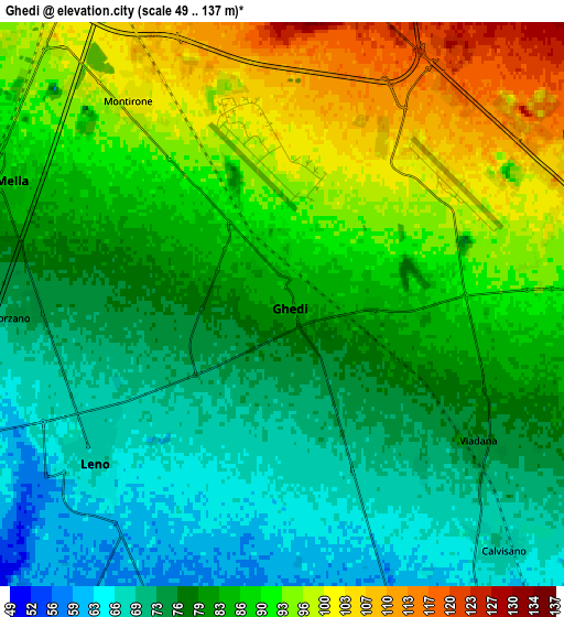
| Scale [m] | 64..105 m | 49..137 m | × |
| Scale [ft] | 210..344 ft | 161..449 ft | × |
| Average | 81.5 m = 267 ft | 83.6 m = 274 ft | × |
| Width | 6.86 km = 4.3 mi | 13.72 km = 8.5 mi | 219.6 km = 136.5 mi |
| Height | 6.86 km = 4.3 mi | 13.72 km = 8.5 mi | 219.6 km = 136.5 mi |
| ↑Max Latitude | 45.432887° | 45.463717° | 46.38078° |
| Latitude at center | 45.40204° | 45.40204° | 45.40204° |
| ↓Min Latitude | 45.371176° | 45.340296° | 44.40604° |
| ← Min Longitude | 10.232865° | 10.188919° | 8.87056° |
| Longitude center | 10.27681° | 10.27681° | 10.27681° |
| →Max Longitude | 10.320755° | 10.364701° | 11.68306° |
Nearby cities:
Cities around Ghedi sort by population:
• Montichiari elevation 104 m
9.5 km,  82°
82°
• Bagnolo Mella 86 m
7.6 km,  291°
291°
• Leno 65 m
5.9 km,  232°
232°
• Borgosatollo 115 m
8.8 km,  341°
341°
• Castenedolo 127 m
8.1 km,  8°
8°
• Montirone 101 m
6.2 km,  322°
322°
• Poncarale 95 m
10 km,  310°
310°
• Calvisano 67 m
8.1 km,  140°
140°
• Vighizzolo 111 m
7.1 km,  58°
58°
• Castelletto 59 m
8.5 km,  203°
203°
• Viadana 76 m
5.7 km,  125°
125°
• Sant'Antonio 93 m
6.2 km,  87°
87°
Multilingual:
 En español:
Ghedi elevación 85 m.
 En France:
Ghedi élévation 85 m.


Sources and notes:
- [note 1] Map square and city borders are not equal. Map elevation data is calculated only from area inside that square.
- [src 1] Elevation data from geonames database provided with same terms of usage.
- [src 2] The elevation map of Ghedi is generated using elevation data from NASA's 3 arcsec (90m) resolution SRTM data.
- [src 3] Base (background) map © OpenStreetMap contributors tiles are generated by Geofabrik and OpenTopoMap.
Copyright & License:
This Ghedi Elevation Map is licensed under CC BY-SA. You may reuse any part from this page, if you give a proper credit by linking to this URL:
 More info on terms of use page.