Sant'Antonio elevation
Sant'Antonio (Lombardy, Provincia di Brescia), Italy elevation is 93 meters and Sant'Antonio elevation in feet is 305 ft above sea level [src 1]. Sant'Antonio is a populated place (feature code) with elevation that is 229 meters (751 ft) smaller than average city elevation in Italy.
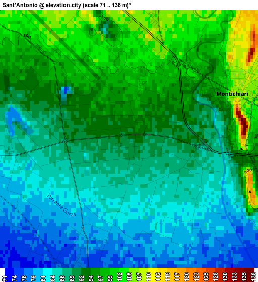
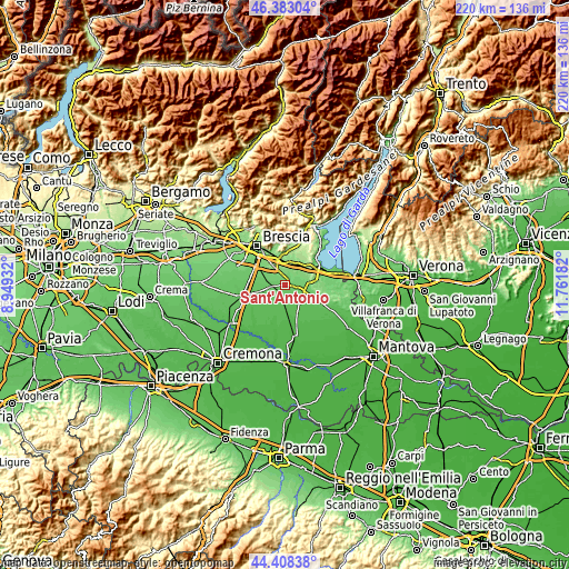
Below is the Elevation map of Sant'Antonio, which displays elevation range with different colors. Scale of the first map is from 71 to 138 m (233 to 453 ft) with average elevation of 90.6 meters (=297 ft) [note 1]
These maps also provides idea of topography and contour of this city, they are displayed at different zoom levels. More info about maps, scale and edge coordinates you can find below images.
| \ | Map #1 | Topo.Map |
| Scale [m] | 71..138 m | × |
| Scale [ft] | 233..453 ft | × |
| Average | 90.6 m = 297 ft | × |
| Width | 6.86 km = 4.3 mi | 219.6 km = 136.5 mi |
| Height | 6.86 km = 4.3 mi | 219.5 km = 136.4 mi |
| ↑Max Latitude | 45.435186° | 46.38304° |
| Latitude at center | 45.40434° | 45.40434° |
| ↓Min Latitude | 45.373478° | 44.40838° |
| ← Min Longitude | 10.311625° | 8.94932° |
| Longitude center | 10.35557° | 10.35557° |
| →Max Longitude | 10.399515° | 11.76182° |
Nearby cities:
Cities around Sant'Antonio sort by population:
• Ghedi elevation 85 m
6.2 km,  267°
267°
• Montichiari 104 m
3.5 km,  73°
73°
• Carpenedolo 77 m
7.6 km,  128°
128°
• Calcinato 127 m
7.2 km,  35°
35°
• Molinetto 147 m
10 km,  1°
1°
• Castenedolo 127 m
9.3 km,  327°
327°
• Calvisano 67 m
6.6 km,  188°
188°
• Vighizzolo 111 m
3.4 km,  359°
359°
• Ponte San Marco 148 m
9.2 km,  29°
29°
• Visano 58 m
9.8 km,  172°
172°
• Novagli 86 m
6.8 km,  106°
106°
• Viadana 76 m
3.9 km,  202°
202°
Multilingual:
 En español:
Sant'Antonio elevación 93 m.
 En France:
Sant'Antonio élévation 93 m.
 Auf Deutsch:
Sant'Antonio höhe über dem Meeresspiegel ist 93 m.

Sources and notes:
- [note 1] Map square and city borders are not equal. Map elevation data is calculated only from area inside that square.
- [src 1] Elevation data from geonames database provided with same terms of usage.
- [src 2] The elevation map of Sant'Antonio is generated using elevation data from NASA's 3 arcsec (90m) resolution SRTM data.
- [src 3] Base (background) map © OpenStreetMap contributors tiles are generated by Geofabrik and OpenTopoMap.
Copyright & License:
This Sant'Antonio Elevation Map is licensed under CC BY-SA. You may reuse any part from this page, if you give a proper credit by linking to this URL:
 More info on terms of use page.