Giarole elevation
Giarole (Piedmont, Provincia di Alessandria), Italy elevation is 102 meters and Giarole elevation in feet is 335 ft above sea level [src 1]. Giarole is a seat of a third-order administrative division (feature code) with elevation that is 220 meters (722 ft) smaller than average city elevation in Italy.
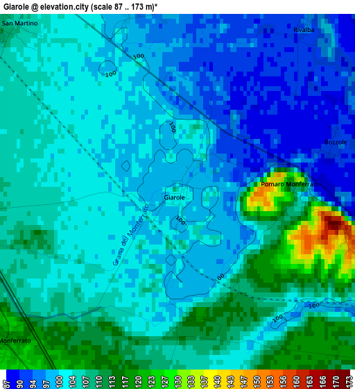
Below is the Elevation map of Giarole, which displays elevation range with different colors. Scale of the first map is from 87 to 173 m (285 to 568 ft) with average elevation of 103.6 meters (=340 ft) [note 1]
These maps also provides idea of topography and contour of this city, they are displayed at different zoom levels. More info about maps, scale and edge coordinates you can find below images.
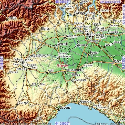
| \ | Map #1 | Topo.Map |
| Scale [m] | 87..173 m | × |
| Scale [ft] | 285..568 ft | × |
| Average | 103.6 m = 340 ft | × |
| Width | 6.9 km = 4.3 mi | 220.9 km = 137.3 mi |
| Height | 6.9 km = 4.3 mi | 220.9 km = 137.3 mi |
| ↑Max Latitude | 45.092512° | 46.04615° |
| Latitude at center | 45.06148° | 45.06148° |
| ↓Min Latitude | 45.030431° | 44.05955° |
| ← Min Longitude | 8.523355° | 7.16105° |
| Longitude center | 8.5673° | 8.5673° |
| →Max Longitude | 8.611245° | 9.97355° |
Nearby cities:
Cities around Giarole sort by population:
• Valenza elevation 134 m
8.1 km,  132°
132°
• San Salvatore Monferrato 217 m
7.4 km,  180°
180°
• Borgo San Martino 107 m
4.9 km,  315°
315°
• Frassineto Po 106 m
8.3 km,  342°
342°
• Ticineto 102 m
4 km, 343°
• Mirabello Monferrato 118 m
4.5 km,  229°
229°
• Occimiano 115 m
4.8 km,  267°
267°
• Breme 105 m
8.7 km,  31°
31°
• Valmacca 96 m
4.6 km,  16°
16°
• Torre Beretti 91 m
8.1 km,  91°
91°
• Bozzole 93 m
3.1 km,  73°
73°
• Pomaro Monferrato 119 m
2.3 km, 87°
Multilingual:
 En español:
Giarole elevación 102 m.
 En France:
Giarole élévation 102 m.


Sources and notes:
- [note 1] Map square and city borders are not equal. Map elevation data is calculated only from area inside that square.
- [src 1] Elevation data from geonames database provided with same terms of usage.
- [src 2] The elevation map of Giarole is generated using elevation data from NASA's 3 arcsec (90m) resolution SRTM data.
- [src 3] Base (background) map © OpenStreetMap contributors tiles are generated by Geofabrik and OpenTopoMap.
Copyright & License:
This Giarole Elevation Map is licensed under CC BY-SA. You may reuse any part from this page, if you give a proper credit by linking to this URL:
 More info on terms of use page.