Occimiano elevation
Occimiano (Piedmont, Provincia di Alessandria), Italy elevation is 115 meters and Occimiano elevation in feet is 377 ft above sea level [src 1]. Occimiano is a seat of a third-order administrative division (feature code) with elevation that is 207 meters (679 ft) smaller than average city elevation in Italy.
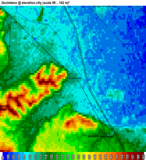
Below is the Elevation map of Occimiano, which displays elevation range with different colors. Scale of the first map is from 98 to 162 m (322 to 531 ft) with average elevation of 115.5 meters (=379 ft) [note 1]
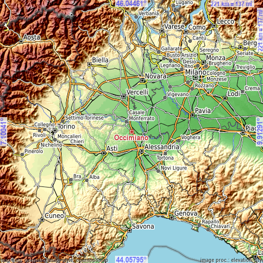
These maps also provides idea of topography and contour of this city, they are displayed at different zoom levels. More info about maps, scale and edge coordinates you can find below images.
| \ | Map #1 | Topo.Map |
| Scale [m] | 98..162 m | × |
| Scale [ft] | 322..531 ft | × |
| Average | 115.5 m = 379 ft | × |
| Width | 6.9 km = 4.3 mi | 220.9 km = 137.3 mi |
| Height | 6.9 km = 4.3 mi | 220.9 km = 137.3 mi |
| ↑Max Latitude | 45.090943° | 46.04461° |
| Latitude at center | 45.05991° | 45.05991° |
| ↓Min Latitude | 45.02886° | 44.05795° |
| ← Min Longitude | 8.462715° | 7.10041° |
| Longitude center | 8.50666° | 8.50666° |
| →Max Longitude | 8.550605° | 9.91291° |
Nearby cities:
Cities around Occimiano sort by population:
• Borgo San Martino elevation 107 m
3.9 km,  20°
20°
• Ticineto 102 m
5.4 km,  42°
42°
• Mirabello Monferrato 118 m
3.1 km,  154°
154°
• Lu 272 m
6.7 km,  194°
194°
• Valmacca 96 m
7.6 km,  52°
52°
• Giarole 102 m
4.8 km,  87°
87°
• Terruggia 179 m
5.5 km,  296°
296°
• Camagna Monferrato 260 m
7.7 km,  232°
232°
• Bozzole 93 m
7.8 km,  82°
82°
• Cuccaro Monferrato 223 m
8.3 km,  207°
207°
• Pomaro Monferrato 119 m
7 km, 87°
• Conzano 253 m
6 km,  222°
222°
Multilingual:
 En español:
Occimiano elevación 115 m.
 En France:
Occimiano élévation 115 m.
 Auf Deutsch:
Occimiano höhe über dem Meeresspiegel ist 115 m.

Sources and notes:
- [note 1] Map square and city borders are not equal. Map elevation data is calculated only from area inside that square.
- [src 1] Elevation data from geonames database provided with same terms of usage.
- [src 2] The elevation map of Occimiano is generated using elevation data from NASA's 3 arcsec (90m) resolution SRTM data.
- [src 3] Base (background) map © OpenStreetMap contributors tiles are generated by Geofabrik and OpenTopoMap.
Copyright & License:
This Occimiano Elevation Map is licensed under CC BY-SA. You may reuse any part from this page, if you give a proper credit by linking to this URL:
 More info on terms of use page.