Lu elevation
Lu (Piedmont, Provincia di Alessandria), Italy elevation is 272 meters and Lu elevation in feet is 892 ft above sea level [src 1]. Lu is a seat of a third-order administrative division (feature code) with elevation that is 50 meters (164 ft) smaller than average city elevation in Italy.
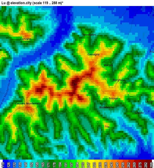
Below is the Elevation map of Lu, which displays elevation range with different colors. Scale of the first map is from 119 to 288 m (390 to 945 ft) with average elevation of 172.6 meters (=566 ft) [note 1]
These maps also provides idea of topography and contour of this city, they are displayed at different zoom levels. More info about maps, scale and edge coordinates you can find below images.
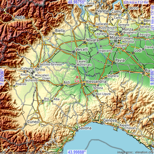
| \ | Map #1 | Topo.Map |
| Scale [m] | 119..288 m | × |
| Scale [ft] | 390..945 ft | × |
| Average | 172.6 m = 566 ft | × |
| Width | 6.91 km = 4.3 mi | 221.1 km = 137.4 mi |
| Height | 6.91 km = 4.3 mi | 221.1 km = 137.4 mi |
| ↑Max Latitude | 45.032905° | 45.98755° |
| Latitude at center | 45.00184° | 45.00184° |
| ↓Min Latitude | 44.970759° | 43.99888° |
| ← Min Longitude | 8.441665° | 7.07936° |
| Longitude center | 8.48561° | 8.48561° |
| →Max Longitude | 8.529555° | 9.89186° |
Nearby cities:
Cities around Lu sort by population:
• San Salvatore Monferrato elevation 217 m
6.4 km,  96°
96°
• Mirabello Monferrato 118 m
4.8 km,  39°
39°
• Fubine 161 m
6.2 km,  226°
226°
• Occimiano 115 m
6.7 km,  14°
14°
• Quargnento 119 m
6.2 km,  178°
178°
• Castelletto Monferrato 183 m
6.6 km,  110°
110°
• Vignale Monferrato 286 m
7 km,  277°
277°
• Frassinello Monferrato 240 m
8.5 km,  294°
294°
• Camagna Monferrato 260 m
4.7 km, 291°
• Cuccaro Monferrato 223 m
2.4 km,  247°
247°
• Conzano 253 m
3.1 km,  310°
310°
• Altavilla Monferrato 241 m
8.7 km,  263°
263°
Multilingual:
 En español:
Lu elevación 272 m.
 En France:
Lu élévation 272 m.


Sources and notes:
- [note 1] Map square and city borders are not equal. Map elevation data is calculated only from area inside that square.
- [src 1] Elevation data from geonames database provided with same terms of usage.
- [src 2] The elevation map of Lu is generated using elevation data from NASA's 3 arcsec (90m) resolution SRTM data.
- [src 3] Base (background) map © OpenStreetMap contributors tiles are generated by Geofabrik and OpenTopoMap.
Copyright & License:
This Lu Elevation Map is licensed under CC BY-SA. You may reuse any part from this page, if you give a proper credit by linking to this URL:
 More info on terms of use page.