Terruggia elevation
Terruggia (Piedmont, Provincia di Alessandria), Italy elevation is 179 meters and Terruggia elevation in feet is 587 ft above sea level [src 1]. Terruggia is a seat of a third-order administrative division (feature code) with elevation that is 143 meters (469 ft) smaller than average city elevation in Italy.
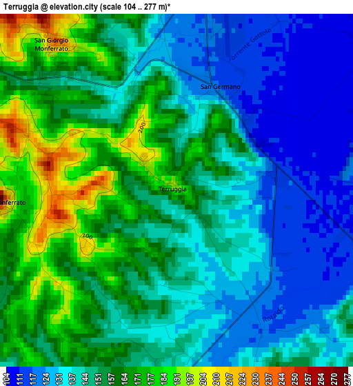
Below is the Elevation map of Terruggia, which displays elevation range with different colors. Scale of the first map is from 104 to 277 m (341 to 909 ft) with average elevation of 148.9 meters (=489 ft) [note 1]
These maps also provides idea of topography and contour of this city, they are displayed at different zoom levels. More info about maps, scale and edge coordinates you can find below images.
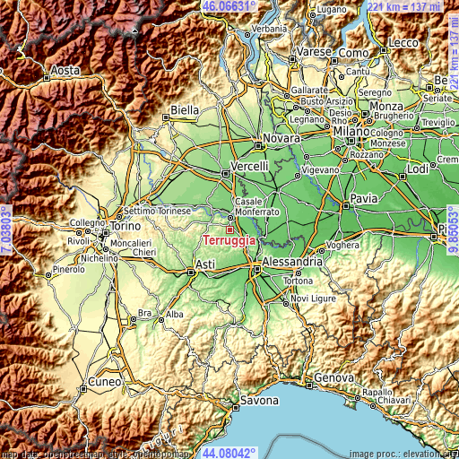
| \ | Map #1 | Topo.Map |
| Scale [m] | 104..277 m | × |
| Scale [ft] | 341..909 ft | × |
| Average | 148.9 m = 489 ft | × |
| Width | 6.9 km = 4.3 mi | 220.8 km = 137.2 mi |
| Height | 6.9 km = 4.3 mi | 220.8 km = 137.2 mi |
| ↑Max Latitude | 45.113011° | 46.06631° |
| Latitude at center | 45.08199° | 45.08199° |
| ↓Min Latitude | 45.050952° | 44.08042° |
| ← Min Longitude | 8.400335° | 7.03803° |
| Longitude center | 8.44428° | 8.44428° |
| →Max Longitude | 8.488225° | 9.85053° |
Nearby cities:
Cities around Terruggia sort by population:
• Casale Monferrato elevation 123 m
5.8 km,  6°
6°
• Borgo San Martino 107 m
6.3 km,  79°
79°
• San Giorgio Monferrato 226 m
3.6 km,  321°
321°
• Occimiano 115 m
5.5 km,  116°
116°
• Ozzano Monferrato 198 m
6.2 km,  295°
295°
• San Giorgio 230 m
3.7 km, 320°
• Frassinello Monferrato 240 m
7.1 km,  219°
219°
• Rosignano Monferrato 277 m
3.5 km,  267°
267°
• Cella Monte 251 m
4.2 km,  257°
257°
• Sala Monferrato 222 m
6.6 km, 263°
• Conzano 253 m
6.9 km,  172°
172°
• Treville 268 m
6.9 km,  283°
283°
Multilingual:
 En español:
Terruggia elevación 179 m.
 En France:
Terruggia élévation 179 m.
 Auf Deutsch:
Terruggia höhe über dem Meeresspiegel ist 179 m.

Sources and notes:
- [note 1] Map square and city borders are not equal. Map elevation data is calculated only from area inside that square.
- [src 1] Elevation data from geonames database provided with same terms of usage.
- [src 2] The elevation map of Terruggia is generated using elevation data from NASA's 3 arcsec (90m) resolution SRTM data.
- [src 3] Base (background) map © OpenStreetMap contributors tiles are generated by Geofabrik and OpenTopoMap.
Copyright & License:
This Terruggia Elevation Map is licensed under CC BY-SA. You may reuse any part from this page, if you give a proper credit by linking to this URL:
 More info on terms of use page.