Torre Beretti elevation
Torre Beretti (Lombardy, Provincia di Pavia), Italy elevation is 91 meters and Torre Beretti elevation in feet is 299 ft above sea level [src 1]. Torre Beretti is a seat of a third-order administrative division (feature code) with elevation that is 231 meters (758 ft) smaller than average city elevation in Italy.
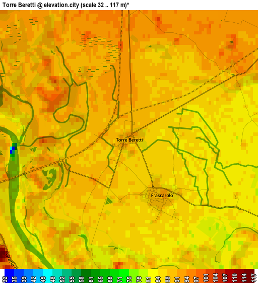
Below is the Elevation map of Torre Beretti, which displays elevation range with different colors. Scale of the first map is from 32 to 117 m (105 to 384 ft) with average elevation of 88.2 meters (=289 ft) [note 1]
These maps also provides idea of topography and contour of this city, they are displayed at different zoom levels. More info about maps, scale and edge coordinates you can find below images.
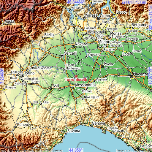
| \ | Map #1 | Topo.Map |
| Scale [m] | 32..117 m | × |
| Scale [ft] | 105..384 ft | × |
| Average | 88.2 m = 289 ft | × |
| Width | 6.9 km = 4.3 mi | 220.9 km = 137.3 mi |
| Height | 6.9 km = 4.3 mi | 220.9 km = 137.3 mi |
| ↑Max Latitude | 45.090993° | 46.04466° |
| Latitude at center | 45.05996° | 45.05996° |
| ↓Min Latitude | 45.02891° | 44.058° |
| ← Min Longitude | 8.626995° | 7.26469° |
| Longitude center | 8.67094° | 8.67094° |
| →Max Longitude | 8.714885° | 10.07719° |
Nearby cities:
Cities around Torre Beretti sort by population:
• Valenza elevation 134 m
5.7 km,  201°
201°
• Mede 97 m
6.6 km,  51°
51°
• Sartirana Lomellina 99 m
6 km,  357°
357°
• Bassignana 98 m
8.2 km,  143°
143°
• Frascarolo 92 m
1.7 km,  149°
149°
• Valmacca 96 m
8.2 km,  303°
303°
• Giarole 102 m
8.1 km,  271°
271°
• Suardi 84 m
6.3 km,  118°
118°
• Pecetto di Valenza 194 m
7.9 km,  180°
180°
• Bozzole 93 m
5.2 km,  281°
281°
• Pomaro Monferrato 119 m
5.9 km, 272°
• Gambarana 84 m
8 km, 115°
Multilingual:
 En español:
Torre Beretti elevación 91 m.
 En France:
Torre Beretti élévation 91 m.
 Auf Deutsch:
Torre Beretti höhe über dem Meeresspiegel ist 91 m.

Sources and notes:
- [note 1] Map square and city borders are not equal. Map elevation data is calculated only from area inside that square.
- [src 1] Elevation data from geonames database provided with same terms of usage.
- [src 2] The elevation map of Torre Beretti is generated using elevation data from NASA's 3 arcsec (90m) resolution SRTM data.
- [src 3] Base (background) map © OpenStreetMap contributors tiles are generated by Geofabrik and OpenTopoMap.
Copyright & License:
This Torre Beretti Elevation Map is licensed under CC BY-SA. You may reuse any part from this page, if you give a proper credit by linking to this URL:
 More info on terms of use page.