Issime elevation
Issime (Aosta Valley, Valle d'Aosta), Italy elevation is 958 meters and Issime elevation in feet is 3143 ft above sea level [src 1]. Issime is a seat of a third-order administrative division (feature code) with elevation that is 636 meters (2087 ft) bigger than average city elevation in Italy.
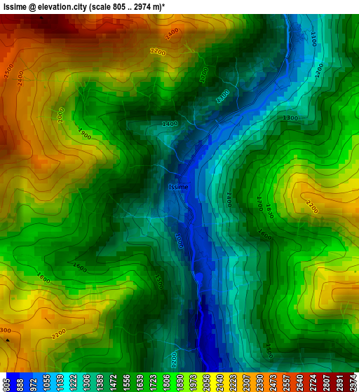
Below is the Elevation map of Issime, which displays elevation range with different colors. Scale of the first map is from 805 to 2974 m (2641 to 9757 ft) with average elevation of 1701.5 meters (=5582 ft) [note 1]
These maps also provides idea of topography and contour of this city, they are displayed at different zoom levels. More info about maps, scale and edge coordinates you can find below images.
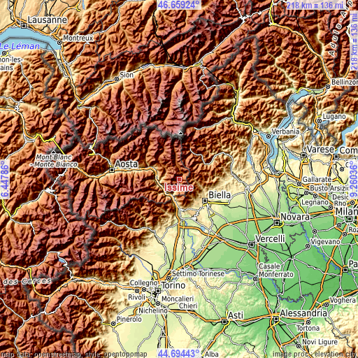
| \ | Map #1 | Topo.Map |
| Scale [m] | 805..2974 m | × |
| Scale [ft] | 2641..9757 ft | × |
| Average | 1701.5 m = 5582 ft | × |
| Width | 6.83 km = 4.2 mi | 218.5 km = 135.8 mi |
| Height | 6.83 km = 4.2 mi | 218.5 km = 135.8 mi |
| ↑Max Latitude | 45.716152° | 46.65924° |
| Latitude at center | 45.68546° | 45.68546° |
| ↓Min Latitude | 45.654752° | 44.69443° |
| ← Min Longitude | 7.810165° | 6.44786° |
| Longitude center | 7.85411° | 7.85411° |
| →Max Longitude | 7.898055° | 9.26036° |
Nearby cities:
Cities around Issime sort by population:
• Pont-Saint-Martin elevation 328 m
11 km,  204°
204°
• Donnas 316 m
11.1 km,  213°
213°
• Arnad 354 m
11.5 km,  248°
248°
• Challand-Saint-Anselme 1051 m
9.8 km,  289°
289°
• Gressoney-Saint-Jean 1383 m
9.9 km,  348°
348°
• Gaby 1054 m
3.8 km,  35°
35°
• Lillianes 669 m
6.3 km,  189°
189°
• Quincod 1048 m
9.8 km, 289°
• Piedicavallo 1064 m
7.8 km,  86°
86°
• Fontainemore 767 m
4.2 km,  174°
174°
• Rosazza 889 m
9.6 km,  96°
96°
• Perloz 664 m
8.7 km, 204°
Multilingual:
 En español:
Issime elevación 958 m.
 En France:
Issime élévation 958 m.


Sources and notes:
- [note 1] Map square and city borders are not equal. Map elevation data is calculated only from area inside that square.
- [src 1] Elevation data from geonames database provided with same terms of usage.
- [src 2] The elevation map of Issime is generated using elevation data from NASA's 3 arcsec (90m) resolution SRTM data.
- [src 3] Base (background) map © OpenStreetMap contributors tiles are generated by Geofabrik and OpenTopoMap.
Copyright & License:
This Issime Elevation Map is licensed under CC BY-SA. You may reuse any part from this page, if you give a proper credit by linking to this URL:
 More info on terms of use page.