Gressoney-Saint-Jean elevation
Gressoney-Saint-Jean (Aosta Valley, Valle d'Aosta), Italy elevation is 1383 meters and Gressoney-Saint-Jean elevation in feet is 4537 ft above sea level [src 1]. Gressoney-Saint-Jean is a seat of a third-order administrative division (feature code) with elevation that is 1061 meters (3481 ft) bigger than average city elevation in Italy.
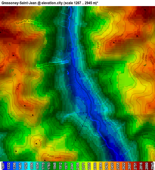
Below is the Elevation map of Gressoney-Saint-Jean, which displays elevation range with different colors. Scale of the first map is from 1267 to 2945 m (4157 to 9662 ft) with average elevation of 2053.8 meters (=6738 ft) [note 1]
These maps also provides idea of topography and contour of this city, they are displayed at different zoom levels. More info about maps, scale and edge coordinates you can find below images.
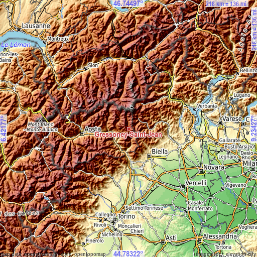
| \ | Map #1 | Topo.Map |
| Scale [m] | 1267..2945 m | × |
| Scale [ft] | 4157..9662 ft | × |
| Average | 2053.8 m = 6738 ft | × |
| Width | 6.82 km = 4.2 mi | 218.1 km = 135.5 mi |
| Height | 6.82 km = 4.2 mi | 218.1 km = 135.5 mi |
| ↑Max Latitude | 45.803364° | 46.74497° |
| Latitude at center | 45.77272° | 45.77272° |
| ↓Min Latitude | 45.742059° | 44.78322° |
| ← Min Longitude | 7.784075° | 6.42177° |
| Longitude center | 7.82802° | 7.82802° |
| →Max Longitude | 7.871965° | 9.23427° |
Nearby cities:
Cities around Gressoney-Saint-Jean sort by population:
• Ayas elevation 1708 m
11.8 km,  293°
293°
• Challand-Saint-Anselme 1051 m
9.7 km,  228°
228°
• Challand-Saint-Victor 789 m
13.2 km, 226°
• Brusson 1339 m
7.8 km,  258°
258°
• Gaby 1054 m
7.9 km,  147°
147°
• Alagna Valsesia 1170 m
12.2 km,  43°
43°
• Quincod 1048 m
9.7 km, 228°
• Antagnod 1708 m
11.7 km, 293°
• Gressoney-La-Trinitè 1633 m
6.3 km,  356°
356°
• Riva Valdobbia 1084 m
11.9 km,  56°
56°
• Issime 958 m
9.9 km,  168°
168°
• Emarese 981 m
12 km,  243°
243°
Multilingual:
 En español:
Gressoney-Saint-Jean elevación 1383 m.
 En France:
Gressoney-Saint-Jean élévation 1383 m.
 Auf Deutsch:
Gressoney-Saint-Jean höhe über dem Meeresspiegel ist 1383 m.
 На русском:
Gressoney-Saint-Jean высота над уровнем моря 1383 м
Sources and notes:
- [note 1] Map square and city borders are not equal. Map elevation data is calculated only from area inside that square.
- [src 1] Elevation data from geonames database provided with same terms of usage.
- [src 2] The elevation map of Gressoney-Saint-Jean is generated using elevation data from NASA's 3 arcsec (90m) resolution SRTM data.
- [src 3] Base (background) map © OpenStreetMap contributors tiles are generated by Geofabrik and OpenTopoMap.
Copyright & License:
This Gressoney-Saint-Jean Elevation Map is licensed under CC BY-SA. You may reuse any part from this page, if you give a proper credit by linking to this URL:
 More info on terms of use page.