Emarese elevation
Emarese (Aosta Valley, Valle d'Aosta), Italy elevation is 981 meters and Emarese elevation in feet is 3219 ft above sea level [src 1]. Emarese is a seat of a third-order administrative division (feature code) with elevation that is 659 meters (2162 ft) bigger than average city elevation in Italy.
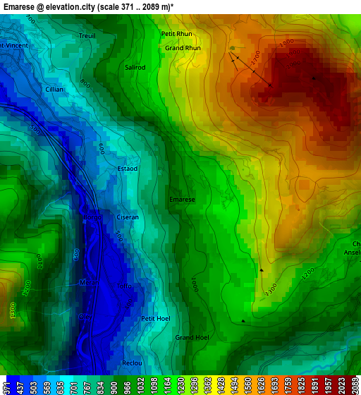
Below is the Elevation map of Emarese, which displays elevation range with different colors. Scale of the first map is from 371 to 2089 m (1217 to 6854 ft) with average elevation of 1055.7 meters (=3464 ft) [note 1]
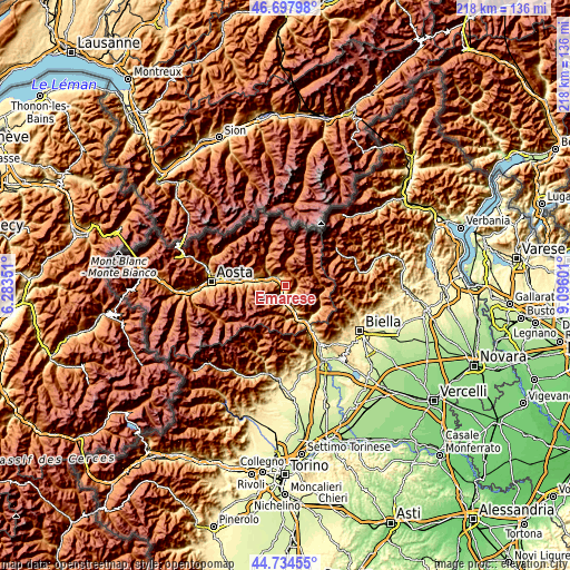
These maps also provides idea of topography and contour of this city, they are displayed at different zoom levels. More info about maps, scale and edge coordinates you can find below images.
| \ | Map #1 | Topo.Map |
| Scale [m] | 371..2089 m | × |
| Scale [ft] | 1217..6854 ft | × |
| Average | 1055.7 m = 3464 ft | × |
| Width | 6.82 km = 4.2 mi | 218.3 km = 135.6 mi |
| Height | 6.82 km = 4.2 mi | 218.3 km = 135.6 mi |
| ↑Max Latitude | 45.75556° | 46.69798° |
| Latitude at center | 45.72489° | 45.72489° |
| ↓Min Latitude | 45.694203° | 44.73455° |
| ← Min Longitude | 7.645815° | 6.28351° |
| Longitude center | 7.68976° | 7.68976° |
| →Max Longitude | 7.733705° | 9.09601° |
Nearby cities:
Cities around Emarese sort by population:
• Chatillon elevation 513 m
6.3 km,  296°
296°
• Saint-Vincent 571 m
4.3 km,  311°
311°
• Verres 382 m
6.5 km,  180°
180°
• Montjovet 384 m
2.2 km,  212°
212°
• Issogne 380 m
7.8 km, 182°
• Challand-Saint-Anselme 1051 m
3.7 km,  108°
108°
• Challand-Saint-Victor 789 m
4 km,  163°
163°
• Berriat 389 m
2.2 km, 208°
• Brusson 1339 m
4.9 km,  38°
38°
• Villa-Nabian 775 m
4.1 km, 163°
• Quincod 1048 m
3.7 km, 107°
• Champdepraz 550 m
5.1 km, 210°
Multilingual:
 En español:
Emarese elevación 981 m.
 En France:
Émarèse élévation 981 m.


Sources and notes:
- [note 1] Map square and city borders are not equal. Map elevation data is calculated only from area inside that square.
- [src 1] Elevation data from geonames database provided with same terms of usage.
- [src 2] The elevation map of Emarese is generated using elevation data from NASA's 3 arcsec (90m) resolution SRTM data.
- [src 3] Base (background) map © OpenStreetMap contributors tiles are generated by Geofabrik and OpenTopoMap.
Copyright & License:
This Emarese Elevation Map is licensed under CC BY-SA. You may reuse any part from this page, if you give a proper credit by linking to this URL:
 More info on terms of use page.