Saint-Vincent elevation
Saint-Vincent (Aosta Valley, Valle d'Aosta), Italy elevation is 571 meters and Saint-Vincent elevation in feet is 1873 ft above sea level [src 1]. Saint-Vincent is a seat of a third-order administrative division (feature code) with elevation that is 249 meters (817 ft) bigger than average city elevation in Italy.
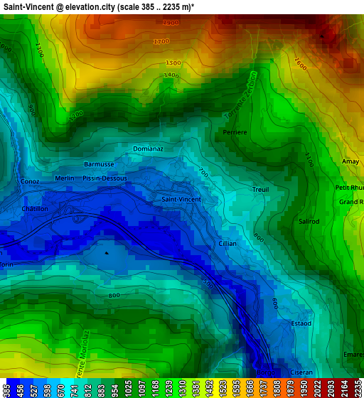
Below is the Elevation map of Saint-Vincent, which displays elevation range with different colors. Scale of the first map is from 385 to 2235 m (1263 to 7333 ft) with average elevation of 1021.2 meters (=3350 ft) [note 1]
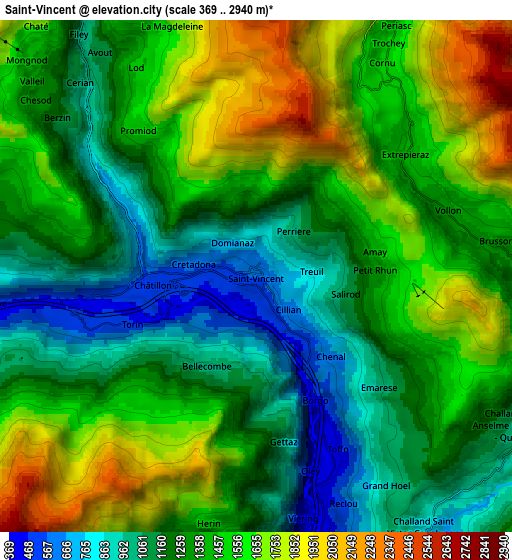
These maps also provides idea of topography and contour of this city, they are displayed at different zoom levels. More info about maps, scale and edge coordinates you can find below images.
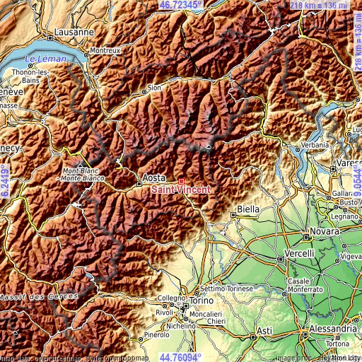
| \ | Map #1 | Map #2 | Topo.Map |
| Scale [m] | 385..2235 m | 369..2940 m | × |
| Scale [ft] | 1263..7333 ft | 1211..9646 ft | × |
| Average | 1021.2 m = 3350 ft | 1379 m = 4524 ft | × |
| Width | 6.82 km = 4.2 mi | 13.64 km = 8.5 mi | 218.2 km = 135.6 mi |
| Height | 6.82 km = 4.2 mi | 13.64 km = 8.5 mi | 218.2 km = 135.6 mi |
| ↑Max Latitude | 45.781476° | 45.812115° | 46.72345° |
| Latitude at center | 45.75082° | 45.75082° | 45.75082° |
| ↓Min Latitude | 45.720147° | 45.689458° | 44.76094° |
| ← Min Longitude | 7.604205° | 7.560259° | 6.2419° |
| Longitude center | 7.64815° | 7.64815° | 7.64815° |
| →Max Longitude | 7.692095° | 7.736041° | 9.0544° |
Nearby cities:
Cities around Saint-Vincent sort by population:
• Chatillon elevation 513 m
2.4 km,  267°
267°
• Montjovet 384 m
5.2 km,  157°
157°
• Ayas 1708 m
7.8 km,  23°
23°
• Pontey 525 m
4.8 km,  254°
254°
• Lassolaz 527 m
4.8 km, 253°
• Berriat 389 m
5.3 km, 155°
• Brusson 1339 m
6.3 km,  81°
81°
• Chambave 490 m
7.7 km,  264°
264°
• Champdepraz 550 m
7.3 km,  174°
174°
• Saint-Denis 813 m
7.2 km, 271°
• La Magdeleine 1639 m
7 km,  340°
340°
• Emarese 981 m
4.3 km,  131°
131°
Multilingual:
 En español:
Saint-Vincent elevación 571 m.
 En France:
Saint-Vincent élévation 571 m.
 Auf Deutsch:
Saint-Vincent höhe über dem Meeresspiegel ist 571 m.

Sources and notes:
- [note 1] Map square and city borders are not equal. Map elevation data is calculated only from area inside that square.
- [src 1] Elevation data from geonames database provided with same terms of usage.
- [src 2] The elevation map of Saint-Vincent is generated using elevation data from NASA's 3 arcsec (90m) resolution SRTM data.
- [src 3] Base (background) map © OpenStreetMap contributors tiles are generated by Geofabrik and OpenTopoMap.
Copyright & License:
This Saint-Vincent Elevation Map is licensed under CC BY-SA. You may reuse any part from this page, if you give a proper credit by linking to this URL:
 More info on terms of use page.