Pont-Saint-Martin elevation
Pont-Saint-Martin (Aosta Valley, Valle d'Aosta), Italy elevation is 328 meters and Pont-Saint-Martin elevation in feet is 1076 ft above sea level [src 1]. Pont-Saint-Martin is a seat of a third-order administrative division (feature code) with elevation that is 6 meters (20 ft) bigger than average city elevation in Italy.
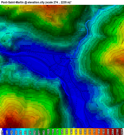
Below is the Elevation map of Pont-Saint-Martin, which displays elevation range with different colors. Scale of the first map is from 274 to 2235 m (899 to 7333 ft) with average elevation of 837.7 meters (=2748 ft) [note 1]
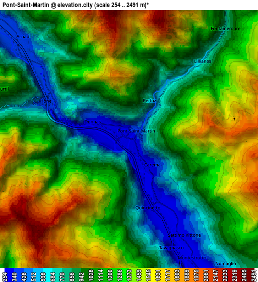
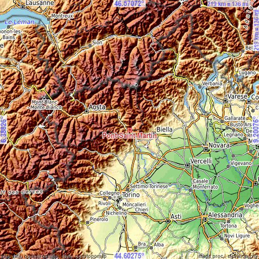
These maps also provides idea of topography and contour of this city, they are displayed at different zoom levels. More info about maps, scale and edge coordinates you can find below images.
| \ | Map #1 | Map #2 | Topo.Map |
| Scale [m] | 274..2235 m | 254..2491 m | × |
| Scale [ft] | 899..7333 ft | 833..8173 ft | × |
| Average | 837.7 m = 2748 ft | 1174.7 m = 3854 ft | × |
| Width | 6.84 km = 4.3 mi | 13.68 km = 8.5 mi | 218.8 km = 136 mi |
| Height | 6.84 km = 4.3 mi | 13.68 km = 8.5 mi | 218.8 km = 136 mi |
| ↑Max Latitude | 45.626101° | 45.656825° | 46.57072° |
| Latitude at center | 45.59536° | 45.59536° | 45.59536° |
| ↓Min Latitude | 45.564602° | 45.533827° | 44.60275° |
| ← Min Longitude | 7.750565° | 7.706619° | 6.38826° |
| Longitude center | 7.79451° | 7.79451° | 7.79451° |
| →Max Longitude | 7.838455° | 7.882401° | 9.20076° |
Nearby cities:
Cities around Pont-Saint-Martin sort by population:
• Donnas elevation 316 m
1.7 km,  298°
298°
• Hone 358 m
4.8 km,  294°
294°
• Quincinetto 287 m
3.9 km,  164°
164°
• Arnad 354 m
8.3 km,  313°
313°
• Settimo Vittone 315 m
5.9 km,  149°
149°
• Tavagnasco 271 m
6.1 km, 158°
• Carema 311 m
1.7 km,  138°
138°
• Lillianes 669 m
5.3 km,  43°
43°
• Nomaglio 575 m
8.3 km, 142°
• Bard 399 m
4.2 km, 291°
• Fontainemore 767 m
7.7 km, 41°
• Perloz 664 m
2.3 km,  27°
27°
Multilingual:
 En español:
Pont-Saint-Martin elevación 328 m.
 En France:
Pont-Saint-Martin élévation 328 m.
 Auf Deutsch:
Pont-Saint-Martin höhe über dem Meeresspiegel ist 328 m.

Sources and notes:
- [note 1] Map square and city borders are not equal. Map elevation data is calculated only from area inside that square.
- [src 1] Elevation data from geonames database provided with same terms of usage.
- [src 2] The elevation map of Pont-Saint-Martin is generated using elevation data from NASA's 3 arcsec (90m) resolution SRTM data.
- [src 3] Base (background) map © OpenStreetMap contributors tiles are generated by Geofabrik and OpenTopoMap.
Copyright & License:
This Pont-Saint-Martin Elevation Map is licensed under CC BY-SA. You may reuse any part from this page, if you give a proper credit by linking to this URL:
 More info on terms of use page.