Hone elevation
Hone (Aosta Valley, Valle d'Aosta), Italy elevation is 358 meters and Hone elevation in feet is 1175 ft above sea level [src 1]. Hone is a seat of a third-order administrative division (feature code) with elevation that is 36 meters (118 ft) bigger than average city elevation in Italy.
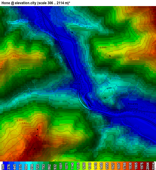
Below is the Elevation map of Hone, which displays elevation range with different colors. Scale of the first map is from 306 to 2114 m (1004 to 6936 ft) with average elevation of 917.1 meters (=3009 ft) [note 1]
These maps also provides idea of topography and contour of this city, they are displayed at different zoom levels. More info about maps, scale and edge coordinates you can find below images.
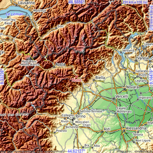
| \ | Map #1 | Topo.Map |
| Scale [m] | 306..2114 m | × |
| Scale [ft] | 1004..6936 ft | × |
| Average | 917.1 m = 3009 ft | × |
| Width | 6.84 km = 4.3 mi | 218.7 km = 135.9 mi |
| Height | 6.84 km = 4.3 mi | 218.7 km = 135.9 mi |
| ↑Max Latitude | 45.644291° | 46.5886° |
| Latitude at center | 45.61356° | 45.61356° |
| ↓Min Latitude | 45.582812° | 44.62127° |
| ← Min Longitude | 7.694565° | 6.33226° |
| Longitude center | 7.73851° | 7.73851° |
| →Max Longitude | 7.782455° | 9.14476° |
Nearby cities:
Cities around Hone sort by population:
• Pont-Saint-Martin elevation 328 m
4.8 km,  114°
114°
• Verres 382 m
7 km,  326°
326°
• Donnas 316 m
3.1 km, 112°
• Issogne 380 m
6.2 km,  318°
318°
• Quincinetto 287 m
7.9 km,  136°
136°
• La Place 399 m
6.2 km, 316°
• Arnad 354 m
4.1 km,  335°
335°
• Carema 311 m
6.4 km,  121°
121°
• Lillianes 669 m
8.2 km,  77°
77°
• Bard 399 m
0.7 km,  133°
133°
• Pont-Bozet 793 m
4.1 km,  260°
260°
• Perloz 664 m
5.4 km,  89°
89°
Multilingual:
 En español:
Hone elevación 358 m.
 En France:
Hone élévation 358 m.


Sources and notes:
- [note 1] Map square and city borders are not equal. Map elevation data is calculated only from area inside that square.
- [src 1] Elevation data from geonames database provided with same terms of usage.
- [src 2] The elevation map of Hone is generated using elevation data from NASA's 3 arcsec (90m) resolution SRTM data.
- [src 3] Base (background) map © OpenStreetMap contributors tiles are generated by Geofabrik and OpenTopoMap.
Copyright & License:
This Hone Elevation Map is licensed under CC BY-SA. You may reuse any part from this page, if you give a proper credit by linking to this URL:
 More info on terms of use page.