Rosazza elevation
Rosazza (Piedmont, Provincia di Biella), Italy elevation is 889 meters and Rosazza elevation in feet is 2917 ft above sea level [src 1]. Rosazza is a seat of a third-order administrative division (feature code) with elevation that is 567 meters (1860 ft) bigger than average city elevation in Italy.
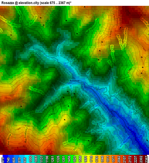
Below is the Elevation map of Rosazza, which displays elevation range with different colors. Scale of the first map is from 675 to 2367 m (2215 to 7766 ft) with average elevation of 1420.6 meters (=4661 ft) [note 1]
These maps also provides idea of topography and contour of this city, they are displayed at different zoom levels. More info about maps, scale and edge coordinates you can find below images.
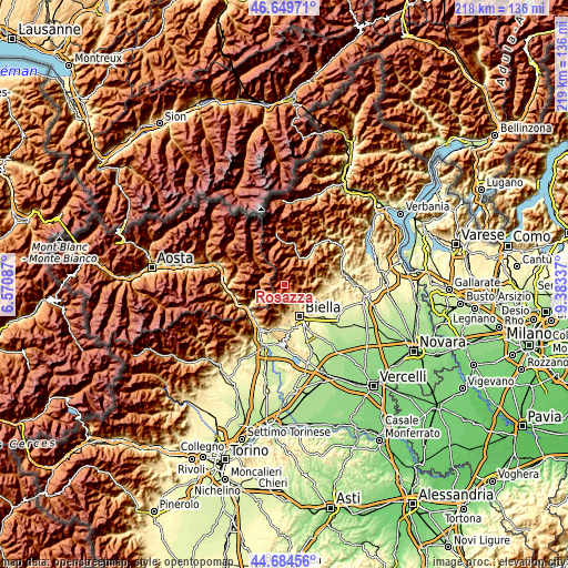
| \ | Map #1 | Topo.Map |
| Scale [m] | 675..2367 m | × |
| Scale [ft] | 2215..7766 ft | × |
| Average | 1420.6 m = 4661 ft | × |
| Width | 6.83 km = 4.2 mi | 218.5 km = 135.8 mi |
| Height | 6.83 km = 4.2 mi | 218.5 km = 135.8 mi |
| ↑Max Latitude | 45.706457° | 46.64971° |
| Latitude at center | 45.67576° | 45.67576° |
| ↓Min Latitude | 45.645046° | 44.68456° |
| ← Min Longitude | 7.933175° | 6.57087° |
| Longitude center | 7.97712° | 7.97712° |
| →Max Longitude | 8.021065° | 9.38337° |
Nearby cities:
Cities around Rosazza sort by population:
• Andorno Cacciorna elevation 549 m
9.5 km,  139°
139°
• Sagliano Micca 586 m
7.6 km, 137°
• Tavigliano 648 m
8.3 km, 135°
• Miagliano 540 m
8.7 km, 142°
• Camandona 802 m
10.2 km,  110°
110°
• Gaby 1054 m
8.5 km,  299°
299°
• Issime 958 m
9.6 km,  276°
276°
• Piedicavallo 1064 m
2.3 km,  312°
312°
• Fontainemore 767 m
9.7 km,  251°
251°
• Campiglia Cervo 777 m
2.3 km,  129°
129°
• Rassa 945 m
10.6 km,  14°
14°
• Callabiana - Chiesa 720 m
10.6 km,  117°
117°
Multilingual:
 En español:
Rosazza elevación 889 m.
 En France:
Rosazza élévation 889 m.


Sources and notes:
- [note 1] Map square and city borders are not equal. Map elevation data is calculated only from area inside that square.
- [src 1] Elevation data from geonames database provided with same terms of usage.
- [src 2] The elevation map of Rosazza is generated using elevation data from NASA's 3 arcsec (90m) resolution SRTM data.
- [src 3] Base (background) map © OpenStreetMap contributors tiles are generated by Geofabrik and OpenTopoMap.
Copyright & License:
This Rosazza Elevation Map is licensed under CC BY-SA. You may reuse any part from this page, if you give a proper credit by linking to this URL:
 More info on terms of use page.