Camandona elevation
Camandona (Piedmont, Provincia di Biella), Italy elevation is 802 meters and Camandona elevation in feet is 2631 ft above sea level [src 1]. Camandona is a seat of a third-order administrative division (feature code) with elevation that is 480 meters (1575 ft) bigger than average city elevation in Italy.
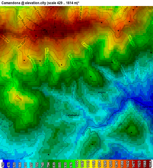
Below is the Elevation map of Camandona, which displays elevation range with different colors. Scale of the first map is from 429 to 1614 m (1407 to 5295 ft) with average elevation of 914.8 meters (=3001 ft) [note 1]
These maps also provides idea of topography and contour of this city, they are displayed at different zoom levels. More info about maps, scale and edge coordinates you can find below images.
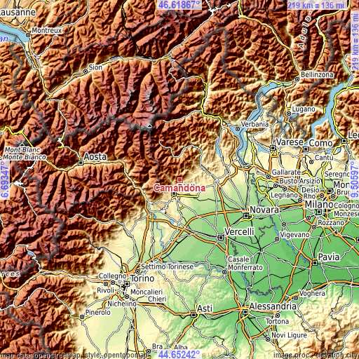
| \ | Map #1 | Topo.Map |
| Scale [m] | 429..1614 m | × |
| Scale [ft] | 1407..5295 ft | × |
| Average | 914.8 m = 3001 ft | × |
| Width | 6.83 km = 4.2 mi | 218.6 km = 135.8 mi |
| Height | 6.83 km = 4.2 mi | 218.6 km = 135.8 mi |
| ↑Max Latitude | 45.674884° | 46.61867° |
| Latitude at center | 45.64417° | 45.64417° |
| ↓Min Latitude | 45.613439° | 44.65242° |
| ← Min Longitude | 8.055775° | 6.69347° |
| Longitude center | 8.09972° | 8.09972° |
| →Max Longitude | 8.143665° | 9.50597° |
Nearby cities:
Cities around Camandona sort by population:
• Valle Mosso elevation 421 m
4 km,  111°
111°
• Mosso 692 m
3 km,  77°
77°
• Pettinengo 713 m
3.5 km,  174°
174°
• Sagliano Micca 586 m
4.8 km,  244°
244°
• Mosso Santa Maria 682 m
2.9 km, 78°
• Livera 676 m
3.6 km, 172°
• Tavigliano 648 m
4.5 km, 236°
• Veglio 745 m
1.2 km, 109°
• Bioglio-Portula-Andrè 594 m
4.3 km,  138°
138°
• Borgo 734 m
1.3 km,  116°
116°
• Selve Marcone 759 m
2.9 km,  199°
199°
• Callabiana - Chiesa 720 m
1.4 km,  187°
187°
Multilingual:
 En español:
Camandona elevación 802 m.
 En France:
Camandona élévation 802 m.
 Auf Deutsch:
Camandona höhe über dem Meeresspiegel ist 802 m.

Sources and notes:
- [note 1] Map square and city borders are not equal. Map elevation data is calculated only from area inside that square.
- [src 1] Elevation data from geonames database provided with same terms of usage.
- [src 2] The elevation map of Camandona is generated using elevation data from NASA's 3 arcsec (90m) resolution SRTM data.
- [src 3] Base (background) map © OpenStreetMap contributors tiles are generated by Geofabrik and OpenTopoMap.
Copyright & License:
This Camandona Elevation Map is licensed under CC BY-SA. You may reuse any part from this page, if you give a proper credit by linking to this URL:
 More info on terms of use page.