Loria Bessica elevation
Loria Bessica (Veneto, Provincia di Treviso), Italy elevation is 69 meters and Loria Bessica elevation in feet is 226 ft above sea level [src 1]. Loria Bessica is a seat of a third-order administrative division (feature code) with elevation that is 253 meters (830 ft) smaller than average city elevation in Italy.
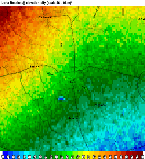
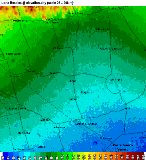
Below is the Elevation map of Loria Bessica, which displays elevation range with different colors. Scale of the first map is from 46 to 96 m (151 to 315 ft) with average elevation of 68.4 meters (=224 ft) [note 1]
These maps also provides idea of topography and contour of this city, they are displayed at different zoom levels. More info about maps, scale and edge coordinates you can find below images.
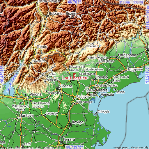
| \ | Map #1 | Map #2 | Topo.Map |
| Scale [m] | 46..96 m | 26..208 m | × |
| Scale [ft] | 151..315 ft | 85..682 ft | × |
| Average | 68.4 m = 224 ft | 74.9 m = 246 ft | × |
| Width | 6.82 km = 4.2 mi | 13.64 km = 8.5 mi | 218.3 km = 135.6 mi |
| Height | 6.82 km = 4.2 mi | 13.64 km = 8.5 mi | 218.3 km = 135.6 mi |
| ↑Max Latitude | 45.760667° | 45.791318° | 46.703° |
| Latitude at center | 45.73° | 45.73° | 45.73° |
| ↓Min Latitude | 45.699316° | 45.668615° | 44.73975° |
| ← Min Longitude | 11.821455° | 11.777509° | 10.45915° |
| Longitude center | 11.8654° | 11.8654° | 11.8654° |
| →Max Longitude | 11.909345° | 11.953291° | 13.27165° |
Nearby cities:
Cities around Loria Bessica sort by population:
• Rossano Veneto elevation 74 m
5.6 km,  238°
238°
• San Zenone degli Ezzelini 116 m
6 km,  338°
338°
• Onè 103 m
6 km,  6°
6°
• Cassola 91 m
5.1 km,  274°
274°
• Riese Pio X 64 m
4.1 km,  92°
92°
• Castello di Godego 57 m
4.3 km,  164°
164°
• Casoni 100 m
5.4 km,  307°
307°
• Vallà 55 m
5.8 km,  115°
115°
• Ca' Rainati 84 m
3.3 km, 340°
• San Vito 77 m
4.8 km,  54°
54°
• Villa d'Asolo 83 m
5.4 km,  29°
29°
• Ramon 63 m
1.8 km,  172°
172°
Multilingual:
 En español:
Loria Bessica elevación 69 m.
 En France:
Loria élévation 69 m.
 Auf Deutsch:
Loria Bessica höhe über dem Meeresspiegel ist 69 m.

Sources and notes:
- [note 1] Map square and city borders are not equal. Map elevation data is calculated only from area inside that square.
- [src 1] Elevation data from geonames database provided with same terms of usage.
- [src 2] The elevation map of Loria Bessica is generated using elevation data from NASA's 3 arcsec (90m) resolution SRTM data.
- [src 3] Base (background) map © OpenStreetMap contributors tiles are generated by Geofabrik and OpenTopoMap.
Copyright & License:
This Loria Bessica Elevation Map is licensed under CC BY-SA. You may reuse any part from this page, if you give a proper credit by linking to this URL:
 More info on terms of use page.