Riese Pio X elevation
Riese Pio X (Veneto, Provincia di Treviso), Italy elevation is 64 meters and Riese Pio X elevation in feet is 210 ft above sea level [src 1]. Riese Pio X is a seat of a third-order administrative division (feature code) with elevation that is 258 meters (846 ft) smaller than average city elevation in Italy.
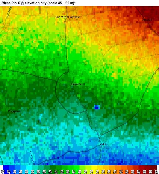
Below is the Elevation map of Riese Pio X, which displays elevation range with different colors. Scale of the first map is from 45 to 92 m (148 to 302 ft) with average elevation of 64.5 meters (=212 ft) [note 1]
These maps also provides idea of topography and contour of this city, they are displayed at different zoom levels. More info about maps, scale and edge coordinates you can find below images.
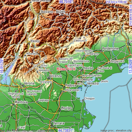
| \ | Map #1 | Topo.Map |
| Scale [m] | 45..92 m | × |
| Scale [ft] | 148..302 ft | × |
| Average | 64.5 m = 212 ft | × |
| Width | 6.82 km = 4.2 mi | 218.3 km = 135.6 mi |
| Height | 6.82 km = 4.2 mi | 218.3 km = 135.6 mi |
| ↑Max Latitude | 45.759248° | 46.7016° |
| Latitude at center | 45.72858° | 45.72858° |
| ↓Min Latitude | 45.697895° | 44.73831° |
| ← Min Longitude | 11.874065° | 10.51176° |
| Longitude center | 11.91801° | 11.91801° |
| →Max Longitude | 11.961955° | 13.32426° |
Nearby cities:
Cities around Riese Pio X sort by population:
• Castelfranco Veneto elevation 46 m
6.4 km,  173°
173°
• Loria Bessica 69 m
4.1 km,  272°
272°
• Asolo 101 m
6.7 km,  359°
359°
• Castello di Godego 57 m
5 km,  216°
216°
• Vallà 55 m
2.6 km,  154°
154°
• Caselle 87 m
5.4 km,  64°
64°
• Ca' Rainati 84 m
6.1 km,  301°
301°
• Fanzolo 60 m
5.9 km,  108°
108°
• San Vito 77 m
3 km, 356°
• Villa d'Asolo 83 m
5 km,  343°
343°
• Altivole 88 m
4.1 km,  46°
46°
• Ramon 63 m
4.2 km,  247°
247°
Multilingual:
 En español:
Riese Pio X elevación 64 m.
 En France:
Riese Pio X élévation 64 m.
 Auf Deutsch:
Riese Pio X höhe über dem Meeresspiegel ist 64 m.

Sources and notes:
- [note 1] Map square and city borders are not equal. Map elevation data is calculated only from area inside that square.
- [src 1] Elevation data from geonames database provided with same terms of usage.
- [src 2] The elevation map of Riese Pio X is generated using elevation data from NASA's 3 arcsec (90m) resolution SRTM data.
- [src 3] Base (background) map © OpenStreetMap contributors tiles are generated by Geofabrik and OpenTopoMap.
Copyright & License:
This Riese Pio X Elevation Map is licensed under CC BY-SA. You may reuse any part from this page, if you give a proper credit by linking to this URL:
 More info on terms of use page.