Caselle elevation
Caselle (Veneto, Provincia di Treviso), Italy elevation is 87 meters and Caselle elevation in feet is 285 ft above sea level [src 1]. Caselle is a populated place (feature code) with elevation that is 235 meters (771 ft) smaller than average city elevation in Italy.
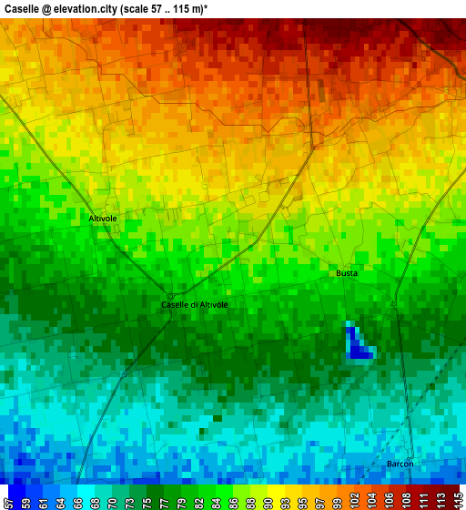
Below is the Elevation map of Caselle, which displays elevation range with different colors. Scale of the first map is from 57 to 115 m (187 to 377 ft) with average elevation of 84.6 meters (=278 ft) [note 1]
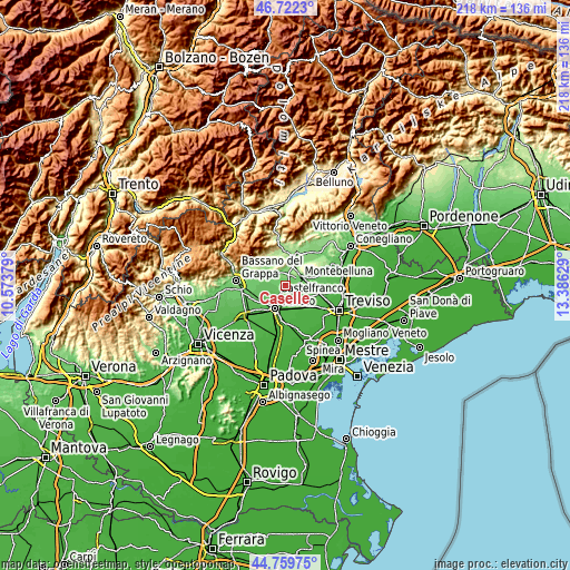
These maps also provides idea of topography and contour of this city, they are displayed at different zoom levels. More info about maps, scale and edge coordinates you can find below images.
| \ | Map #1 | Topo.Map |
| Scale [m] | 57..115 m | × |
| Scale [ft] | 187..377 ft | × |
| Average | 84.6 m = 278 ft | × |
| Width | 6.82 km = 4.2 mi | 218.2 km = 135.6 mi |
| Height | 6.82 km = 4.2 mi | 218.2 km = 135.6 mi |
| ↑Max Latitude | 45.780306° | 46.7223° |
| Latitude at center | 45.74965° | 45.74965° |
| ↓Min Latitude | 45.718977° | 44.75975° |
| ← Min Longitude | 11.936095° | 10.57379° |
| Longitude center | 11.98004° | 11.98004° |
| →Max Longitude | 12.023985° | 13.38629° |
Nearby cities:
Cities around Caselle sort by population:
• Montebelluna elevation 112 m
6.1 km,  62°
62°
• Caerano di San Marco 116 m
3.8 km,  21°
21°
• Vedelago 46 m
7.6 km,  156°
156°
• Asolo 101 m
6.5 km,  311°
311°
• Riese Pio X 64 m
5.4 km,  244°
244°
• Vallà 55 m
6 km,  217°
217°
• Trevignano 75 m
6.9 km,  102°
102°
• Fanzolo 60 m
4.2 km,  169°
169°
• San Vito 77 m
5 km,  276°
276°
• Maser 141 m
6.4 km,  356°
356°
• Villa d'Asolo 83 m
6.7 km,  291°
291°
• Altivole 88 m
1.9 km, 283°
Multilingual:
 En español:
Caselle elevación 87 m.
 En France:
Caselle élévation 87 m.


Sources and notes:
- [note 1] Map square and city borders are not equal. Map elevation data is calculated only from area inside that square.
- [src 1] Elevation data from geonames database provided with same terms of usage.
- [src 2] The elevation map of Caselle is generated using elevation data from NASA's 3 arcsec (90m) resolution SRTM data.
- [src 3] Base (background) map © OpenStreetMap contributors tiles are generated by Geofabrik and OpenTopoMap.
Copyright & License:
This Caselle Elevation Map is licensed under CC BY-SA. You may reuse any part from this page, if you give a proper credit by linking to this URL:
 More info on terms of use page.