Mazzin elevation
Mazzin (Trentino-Alto Adige, Provincia autonoma di Trento), Italy elevation is 1381 meters and Mazzin elevation in feet is 4531 ft above sea level [src 1]. Mazzin is a seat of a third-order administrative division (feature code) with elevation that is 1059 meters (3474 ft) bigger than average city elevation in Italy.
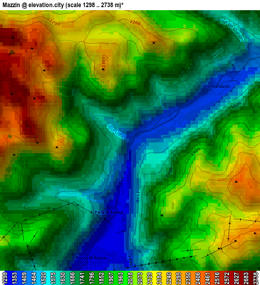
Below is the Elevation map of Mazzin, which displays elevation range with different colors. Scale of the first map is from 1298 to 2738 m (4259 to 8983 ft) with average elevation of 1880 meters (=6168 ft) [note 1]
These maps also provides idea of topography and contour of this city, they are displayed at different zoom levels. More info about maps, scale and edge coordinates you can find below images.
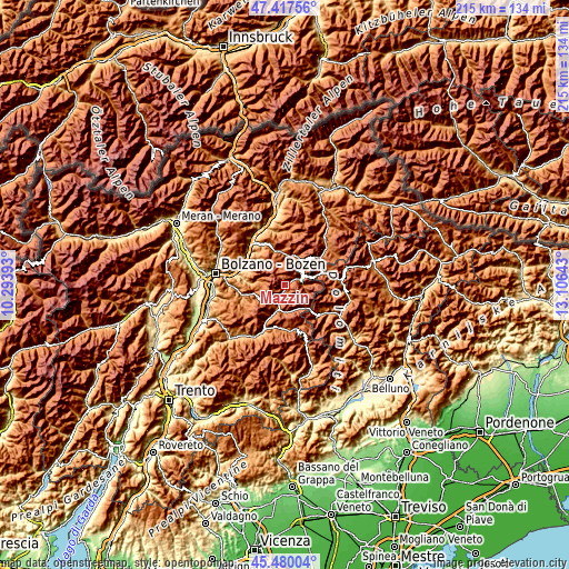
| \ | Map #1 | Topo.Map |
| Scale [m] | 1298..2738 m | × |
| Scale [ft] | 4259..8983 ft | × |
| Average | 1880 m = 6168 ft | × |
| Width | 6.73 km = 4.2 mi | 215.4 km = 133.8 mi |
| Height | 6.73 km = 4.2 mi | 215.4 km = 133.8 mi |
| ↑Max Latitude | 46.487685° | 47.41756° |
| Latitude at center | 46.45742° | 46.45742° |
| ↓Min Latitude | 46.427138° | 45.48004° |
| ← Min Longitude | 11.656235° | 10.29393° |
| Longitude center | 11.70018° | 11.70018° |
| →Max Longitude | 11.744125° | 13.10643° |
Nearby cities:
Cities around Mazzin sort by population:
• Ortisei elevation 1238 m
13.4 km,  350°
350°
• Moena 1175 m
9.5 km,  199°
199°
• Siusi 952 m
14.3 km,  310°
310°
• Selva 1567 m
11.8 km,  23°
23°
• Nova Levante 1148 m
12.7 km,  255°
255°
• Santa Cristina Valgardena 1529 m
12 km,  11°
11°
• Pozza di Fassa 1305 m
3.4 km, 197°
• Vigo di Fassa 1374 m
4.7 km, 204°
• Canazei 1445 m
5.7 km,  68°
68°
• Soraga 1215 m
7.5 km, 200°
• Campitello di Fassa 1423 m
3.7 km,  56°
56°
• Tires 1022 m
13.3 km,  275°
275°
Multilingual:
 En español:
Mazzin elevación 1381 m.
 En France:
Mazzin élévation 1381 m.
 Auf Deutsch:
Mazzin di Fassa höhe über dem Meeresspiegel ist 1381 m.

Sources and notes:
- [note 1] Map square and city borders are not equal. Map elevation data is calculated only from area inside that square.
- [src 1] Elevation data from geonames database provided with same terms of usage.
- [src 2] The elevation map of Mazzin is generated using elevation data from NASA's 3 arcsec (90m) resolution SRTM data.
- [src 3] Base (background) map © OpenStreetMap contributors tiles are generated by Geofabrik and OpenTopoMap.
Copyright & License:
This Mazzin Elevation Map is licensed under CC BY-SA. You may reuse any part from this page, if you give a proper credit by linking to this URL:
 More info on terms of use page.