Nova Levante elevation
Nova Levante (Trentino-Alto Adige, Bolzano), Italy elevation is 1148 meters and Nova Levante elevation in feet is 3766 ft above sea level [src 1]. Nova Levante is a seat of a third-order administrative division (feature code) with elevation that is 826 meters (2710 ft) bigger than average city elevation in Italy.
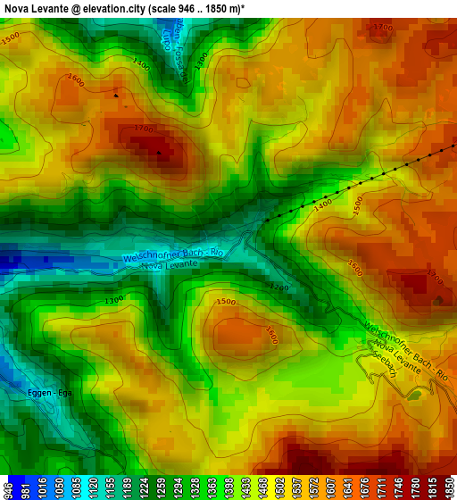
Below is the Elevation map of Nova Levante, which displays elevation range with different colors. Scale of the first map is from 946 to 1850 m (3104 to 6070 ft) with average elevation of 1461.1 meters (=4794 ft) [note 1]
These maps also provides idea of topography and contour of this city, they are displayed at different zoom levels. More info about maps, scale and edge coordinates you can find below images.
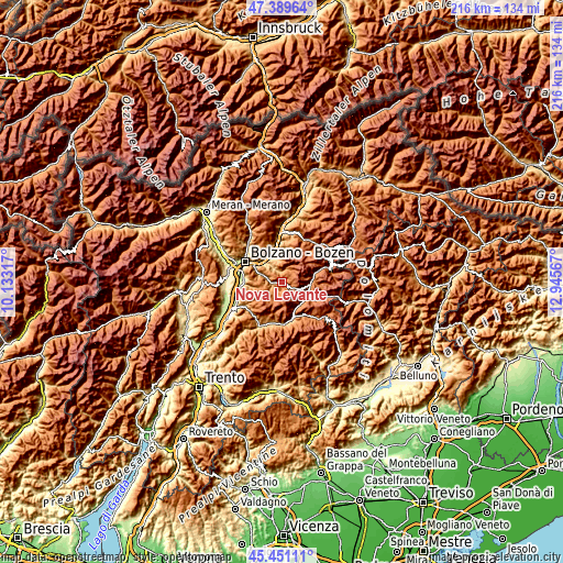
| \ | Map #1 | Topo.Map |
| Scale [m] | 946..1850 m | × |
| Scale [ft] | 3104..6070 ft | × |
| Average | 1461.1 m = 4794 ft | × |
| Width | 6.74 km = 4.2 mi | 215.5 km = 133.9 mi |
| Height | 6.74 km = 4.2 mi | 215.5 km = 133.9 mi |
| ↑Max Latitude | 46.459271° | 47.38964° |
| Latitude at center | 46.42899° | 46.42899° |
| ↓Min Latitude | 46.398692° | 45.45111° |
| ← Min Longitude | 11.495475° | 10.13317° |
| Longitude center | 11.53942° | 11.53942° |
| →Max Longitude | 11.583365° | 12.94567° |
Nearby cities:
Cities around Nova Levante sort by population:
• Moena elevation 1175 m
10.9 km,  122°
122°
• Collalbo 1199 m
13.8 km,  333°
333°
• Siusi 952 m
12.6 km,  6°
6°
• Nova Ponente 1354 m
8.9 km,  259°
259°
• Pozza di Fassa 1305 m
11.3 km,  90°
90°
• Fiè Allo Sciliar 873 m
10.2 km,  343°
343°
• Vigo di Fassa 1374 m
10.4 km,  96°
96°
• Soraga 1215 m
10.4 km,  111°
111°
• Cardano 303 m
13.3 km,  302°
302°
• Tires 1022 m
4.5 km,  347°
347°
• Mazzin 1381 m
12.7 km,  75°
75°
• Cornedo All'Isarco 500 m
12.2 km, 303°
Multilingual:
 En español:
Nova Levante elevación 1148 m.
 En France:
Nova Levante élévation 1148 m.
 Auf Deutsch:
Welschnofen höhe über dem Meeresspiegel ist 1148 m.

Sources and notes:
- [note 1] Map square and city borders are not equal. Map elevation data is calculated only from area inside that square.
- [src 1] Elevation data from geonames database provided with same terms of usage.
- [src 2] The elevation map of Nova Levante is generated using elevation data from NASA's 3 arcsec (90m) resolution SRTM data.
- [src 3] Base (background) map © OpenStreetMap contributors tiles are generated by Geofabrik and OpenTopoMap.
Copyright & License:
This Nova Levante Elevation Map is licensed under CC BY-SA. You may reuse any part from this page, if you give a proper credit by linking to this URL:
 More info on terms of use page.