Cornedo All'Isarco elevation
Cornedo All'Isarco (Trentino-Alto Adige, Bolzano), Italy elevation is 500 meters and Cornedo All'Isarco elevation in feet is 1640 ft above sea level [src 1]. Cornedo All'Isarco is a seat of a third-order administrative division (feature code) with elevation that is 178 meters (584 ft) bigger than average city elevation in Italy.
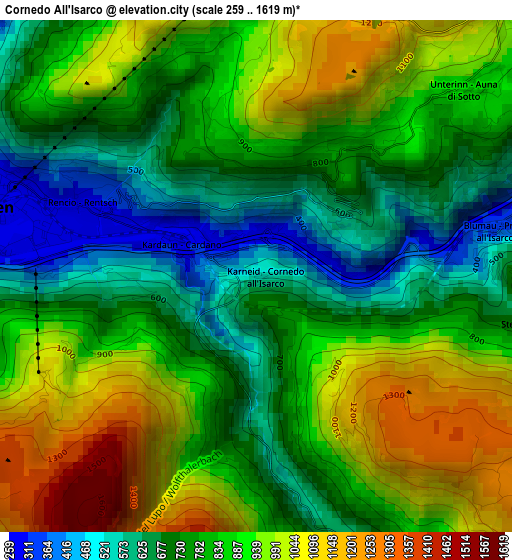
Below is the Elevation map of Cornedo All'Isarco, which displays elevation range with different colors. Scale of the first map is from 259 to 1619 m (850 to 5312 ft) with average elevation of 834.2 meters (=2737 ft) [note 1]
These maps also provides idea of topography and contour of this city, they are displayed at different zoom levels. More info about maps, scale and edge coordinates you can find below images.
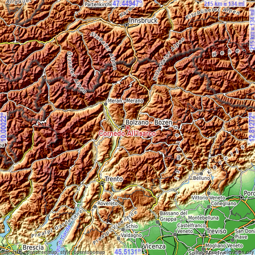
| \ | Map #1 | Topo.Map |
| Scale [m] | 259..1619 m | × |
| Scale [ft] | 850..5312 ft | × |
| Average | 834.2 m = 2737 ft | × |
| Width | 6.73 km = 4.2 mi | 215.3 km = 133.8 mi |
| Height | 6.73 km = 4.2 mi | 215.3 km = 133.8 mi |
| ↑Max Latitude | 46.520147° | 47.44947° |
| Latitude at center | 46.4899° | 46.4899° |
| ↓Min Latitude | 46.459636° | 45.5131° |
| ← Min Longitude | 11.362525° | 10.00022° |
| Longitude center | 11.40647° | 11.40647° |
| →Max Longitude | 11.450415° | 12.81272° |
Nearby cities:
Cities around Cornedo All'Isarco sort by population:
• Bolzano elevation 257 m
5.1 km,  270°
270°
• Laives 250 m
8.7 km,  216°
216°
• Renon - Ritten 1208 m
6.9 km,  34°
34°
• San Giacomo 231 m
6.7 km,  236°
236°
• Collalbo 1199 m
6.9 km,  36°
36°
• Pineta 255 m
7.2 km, 219°
• Nova Ponente 1354 m
8.6 km,  170°
170°
• Fiè Allo Sciliar 873 m
7.8 km,  67°
67°
• San Genesio Atesino 1079 m
7.7 km,  310°
310°
• Soprabolzano 1225 m
4.4 km,  357°
357°
• Cardano 303 m
1.1 km,  290°
290°
• Tires 1022 m
9.5 km,  104°
104°
Multilingual:
 En español:
Cornedo All'Isarco elevación 500 m.
 En France:
Cornedo All'Isarco élévation 500 m.
 Auf Deutsch:
Karneid höhe über dem Meeresspiegel ist 500 m.
 На русском:
Cornedo All'Isarco высота над уровнем моря 500 м
Sources and notes:
- [note 1] Map square and city borders are not equal. Map elevation data is calculated only from area inside that square.
- [src 1] Elevation data from geonames database provided with same terms of usage.
- [src 2] The elevation map of Cornedo All'Isarco is generated using elevation data from NASA's 3 arcsec (90m) resolution SRTM data.
- [src 3] Base (background) map © OpenStreetMap contributors tiles are generated by Geofabrik and OpenTopoMap.
Copyright & License:
This Cornedo All'Isarco Elevation Map is licensed under CC BY-SA. You may reuse any part from this page, if you give a proper credit by linking to this URL:
 More info on terms of use page.