Ortisei elevation
Ortisei (Trentino-Alto Adige, Bolzano), Italy elevation is 1238 meters and Ortisei elevation in feet is 4062 ft above sea level [src 1]. Ortisei is a seat of a third-order administrative division (feature code) with elevation that is 916 meters (3005 ft) bigger than average city elevation in Italy.
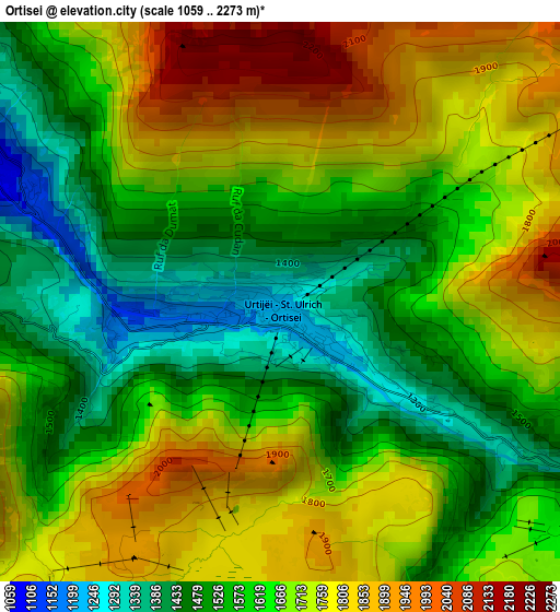
Below is the Elevation map of Ortisei, which displays elevation range with different colors. Scale of the first map is from 1059 to 2273 m (3474 to 7457 ft) with average elevation of 1651.6 meters (=5419 ft) [note 1]
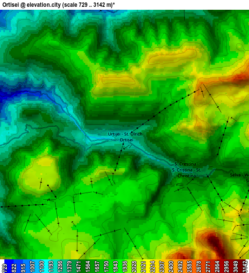
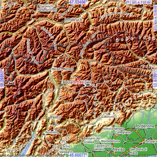
These maps also provides idea of topography and contour of this city, they are displayed at different zoom levels. More info about maps, scale and edge coordinates you can find below images.
| \ | Map #1 | Map #2 | Topo.Map |
| Scale [m] | 1059..2273 m | 729..3142 m | × |
| Scale [ft] | 3474..7457 ft | 2392..10308 ft | × |
| Average | 1651.6 m = 5419 ft | 1730.8 m = 5678 ft | × |
| Width | 6.72 km = 4.2 mi | 13.44 km = 8.4 mi | 215 km = 133.6 mi |
| Height | 6.72 km = 4.2 mi | 13.44 km = 8.4 mi | 215 km = 133.6 mi |
| ↑Max Latitude | 46.606229° | 46.636412° | 47.53406° |
| Latitude at center | 46.57603° | 46.57603° | 46.57603° |
| ↓Min Latitude | 46.545814° | 46.515581° | 45.60077° |
| ← Min Longitude | 11.627815° | 11.583869° | 10.26551° |
| Longitude center | 11.67176° | 11.67176° | 11.67176° |
| →Max Longitude | 11.715705° | 11.759651° | 13.07801° |
Nearby cities:
Cities around Ortisei sort by population:
• Chiusa elevation 535 m
10.8 km,  311°
311°
• Funes - Villnoess 1136 m
7.4 km,  3°
3°
• Siusi 952 m
9.5 km,  245°
245°
• Selva 1567 m
7.2 km,  109°
109°
• Castelrotto 1070 m
8.5 km,  262°
262°
• Barbiano - Barbian 784 m
11.9 km,  284°
284°
• Santa Cristina Valgardena 1529 m
4.8 km, 107°
• Velturno 838 m
11.6 km,  330°
330°
• Laion 1083 m
8.9 km,  293°
293°
• Barbiano 826 m
11.9 km, 285°
• San Pietro 1128 m
7.3 km,  6°
6°
• Ponte Gardena 469 m
11 km, 282°
Multilingual:
 En español:
Ortisei elevación 1238 m.
 En France:
Ortisei élévation 1238 m.
 Auf Deutsch:
St. Ulrich in Gröden, St. Ulrich im Grödnertal höhe über dem Meeresspiegel ist 1238 m.

Sources and notes:
- [note 1] Map square and city borders are not equal. Map elevation data is calculated only from area inside that square.
- [src 1] Elevation data from geonames database provided with same terms of usage.
- [src 2] The elevation map of Ortisei is generated using elevation data from NASA's 3 arcsec (90m) resolution SRTM data.
- [src 3] Base (background) map © OpenStreetMap contributors tiles are generated by Geofabrik and OpenTopoMap.
Copyright & License:
This Ortisei Elevation Map is licensed under CC BY-SA. You may reuse any part from this page, if you give a proper credit by linking to this URL:
 More info on terms of use page.