Selva elevation
Selva (Trentino-Alto Adige, Bolzano), Italy elevation is 1567 meters and Selva elevation in feet is 5141 ft above sea level [src 1]. Selva is a seat of a third-order administrative division (feature code) with elevation that is 1245 meters (4085 ft) bigger than average city elevation in Italy.
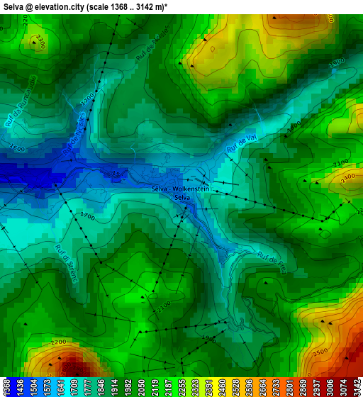
Below is the Elevation map of Selva, which displays elevation range with different colors. Scale of the first map is from 1368 to 3142 m (4488 to 10308 ft) with average elevation of 1968.6 meters (=6459 ft) [note 1]
These maps also provides idea of topography and contour of this city, they are displayed at different zoom levels. More info about maps, scale and edge coordinates you can find below images.
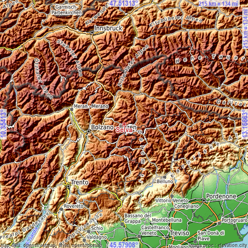
| \ | Map #1 | Topo.Map |
| Scale [m] | 1368..3142 m | × |
| Scale [ft] | 4488..10308 ft | × |
| Average | 1968.6 m = 6459 ft | × |
| Width | 6.72 km = 4.2 mi | 215 km = 133.6 mi |
| Height | 6.72 km = 4.2 mi | 215 km = 133.6 mi |
| ↑Max Latitude | 46.584931° | 47.51313° |
| Latitude at center | 46.55472° | 46.55472° |
| ↓Min Latitude | 46.524492° | 45.57908° |
| ← Min Longitude | 11.716435° | 10.35413° |
| Longitude center | 11.76038° | 11.76038° |
| →Max Longitude | 11.804325° | 13.16663° |
Nearby cities:
Cities around Selva sort by population:
• Ortisei elevation 1238 m
7.2 km,  289°
289°
• Funes - Villnoess 1136 m
11.6 km,  327°
327°
• Siusi 952 m
15.5 km,  264°
264°
• Castelrotto 1070 m
15.3 km,  274°
274°
• Santa Cristina Valgardena 1529 m
2.3 km, 293°
• Pozza di Fassa 1305 m
15.2 km,  201°
201°
• Canazei 1445 m
8.7 km,  175°
175°
• Badia 1345 m
12 km,  60°
60°
• Corvara in Badia 1532 m
8.7 km,  93°
93°
• Campitello di Fassa 1423 m
8.9 km,  189°
189°
• San Pietro 1128 m
11.3 km, 328°
• Mazzin 1381 m
11.8 km, 203°
Multilingual:
 En español:
Selva elevación 1567 m.
 En France:
Selva di Val Gardena élévation 1567 m.
 Auf Deutsch:
Wolkenstein, Wolkenstein in Gröden höhe über dem Meeresspiegel ist 1567 m.

Sources and notes:
- [note 1] Map square and city borders are not equal. Map elevation data is calculated only from area inside that square.
- [src 1] Elevation data from geonames database provided with same terms of usage.
- [src 2] The elevation map of Selva is generated using elevation data from NASA's 3 arcsec (90m) resolution SRTM data.
- [src 3] Base (background) map © OpenStreetMap contributors tiles are generated by Geofabrik and OpenTopoMap.
Copyright & License:
This Selva Elevation Map is licensed under CC BY-SA. You may reuse any part from this page, if you give a proper credit by linking to this URL:
 More info on terms of use page.