Badia elevation
Badia (Trentino-Alto Adige, Bolzano), Italy elevation is 1345 meters and Badia elevation in feet is 4413 ft above sea level [src 1]. Badia is a seat of a third-order administrative division (feature code) with elevation that is 1023 meters (3356 ft) bigger than average city elevation in Italy.
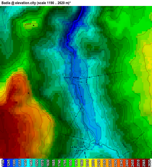
Below is the Elevation map of Badia, which displays elevation range with different colors. Scale of the first map is from 1190 to 2620 m (3904 to 8596 ft) with average elevation of 1742.6 meters (=5717 ft) [note 1]
These maps also provides idea of topography and contour of this city, they are displayed at different zoom levels. More info about maps, scale and edge coordinates you can find below images.
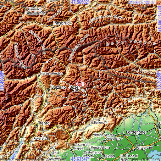
| \ | Map #1 | Topo.Map |
| Scale [m] | 1190..2620 m | × |
| Scale [ft] | 3904..8596 ft | × |
| Average | 1742.6 m = 5717 ft | × |
| Width | 6.71 km = 4.2 mi | 214.8 km = 133.5 mi |
| Height | 6.71 km = 4.2 mi | 214.8 km = 133.5 mi |
| ↑Max Latitude | 46.638341° | 47.56562° |
| Latitude at center | 46.60816° | 46.60816° |
| ↓Min Latitude | 46.577962° | 45.63347° |
| ← Min Longitude | 11.852355° | 10.49005° |
| Longitude center | 11.8963° | 11.8963° |
| →Max Longitude | 11.940245° | 13.30255° |
Nearby cities:
Cities around Badia sort by population:
• Ortisei elevation 1238 m
17.5 km,  258°
258°
• Funes - Villnoess 1136 m
17.1 km,  283°
283°
• Selva 1567 m
12 km,  240°
240°
• Santa Cristina Valgardena 1529 m
13.5 km,  248°
248°
• San Vigilio 1190 m
10.4 km,  14°
14°
• Livinallongo del Col di Lana 1474 m
14.7 km,  162°
162°
• La Valle - Wengen 1347 m
5.9 km,  21°
21°
• Canazei 1445 m
17.6 km,  213°
213°
• Corvara in Badia 1532 m
6.7 km,  195°
195°
• San Pietro 1128 m
16.7 km, 282°
• San Genesio 1364 m
5.9 km, 21°
• San Martino in Badia 1136 m
8.2 km,  0°
0°
Multilingual:
 En español:
Badia elevación 1345 m.
 En France:
Badia élévation 1345 m.


Sources and notes:
- [note 1] Map square and city borders are not equal. Map elevation data is calculated only from area inside that square.
- [src 1] Elevation data from geonames database provided with same terms of usage.
- [src 2] The elevation map of Badia is generated using elevation data from NASA's 3 arcsec (90m) resolution SRTM data.
- [src 3] Base (background) map © OpenStreetMap contributors tiles are generated by Geofabrik and OpenTopoMap.
Copyright & License:
This Badia Elevation Map is licensed under CC BY-SA. You may reuse any part from this page, if you give a proper credit by linking to this URL:
 More info on terms of use page.