Monterosi elevation
Monterosi (Latium, Provincia di Viterbo), Italy elevation is 278 meters and Monterosi elevation in feet is 912 ft above sea level [src 1]. Monterosi is a seat of a third-order administrative division (feature code) with elevation that is 44 meters (144 ft) smaller than average city elevation in Italy.
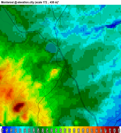
Below is the Elevation map of Monterosi, which displays elevation range with different colors. Scale of the first map is from 172 to 438 m (564 to 1437 ft) with average elevation of 260.9 meters (=856 ft) [note 1]
These maps also provides idea of topography and contour of this city, they are displayed at different zoom levels. More info about maps, scale and edge coordinates you can find below images.
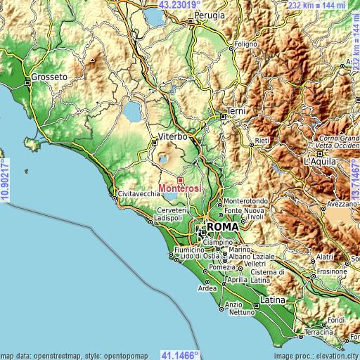
| \ | Map #1 | Topo.Map |
| Scale [m] | 172..438 m | × |
| Scale [ft] | 564..1437 ft | × |
| Average | 260.9 m = 856 ft | × |
| Width | 7.24 km = 4.5 mi | 231.7 km = 144 mi |
| Height | 7.24 km = 4.5 mi | 231.7 km = 144 mi |
| ↑Max Latitude | 42.229528° | 43.23019° |
| Latitude at center | 42.19698° | 42.19698° |
| ↓Min Latitude | 42.164415° | 41.1466° |
| ← Min Longitude | 12.264475° | 10.90217° |
| Longitude center | 12.30842° | 12.30842° |
| →Max Longitude | 12.352365° | 13.71467° |
Nearby cities:
Cities around Monterosi sort by population:
• Campagnano di Roma elevation 307 m
8.7 km,  141°
141°
• Nepi 222 m
5.8 km,  29°
29°
• Sutri 311 m
9.3 km,  305°
305°
• Bassano Romano 374 m
10.3 km,  285°
285°
• Trevignano Romano 174 m
7.1 km,  234°
234°
• Mazzano Romano 226 m
7.2 km,  82°
82°
• Castel Sant'Elia 218 m
7.9 km,  40°
40°
• Faleria 211 m
11.7 km,  74°
74°
• Magliano Romano 266 m
11.4 km,  112°
112°
• Regolelli 199 m
11.3 km,  18°
18°
• Poggio Ellera 260 m
10.6 km,  150°
150°
• Calcata Nuova 220 m
10 km, 75°
Multilingual:
 En español:
Monterosi elevación 278 m.
 En France:
Monterosi élévation 278 m.
 Auf Deutsch:
Monterosi höhe über dem Meeresspiegel ist 278 m.

Sources and notes:
- [note 1] Map square and city borders are not equal. Map elevation data is calculated only from area inside that square.
- [src 1] Elevation data from geonames database provided with same terms of usage.
- [src 2] The elevation map of Monterosi is generated using elevation data from NASA's 3 arcsec (90m) resolution SRTM data.
- [src 3] Base (background) map © OpenStreetMap contributors tiles are generated by Geofabrik and OpenTopoMap.
Copyright & License:
This Monterosi Elevation Map is licensed under CC BY-SA. You may reuse any part from this page, if you give a proper credit by linking to this URL:
 More info on terms of use page.