Poggio Ellera elevation
Poggio Ellera (Latium, Città metropolitana di Roma Capitale), Italy elevation is 260 meters and Poggio Ellera elevation in feet is 853 ft above sea level [src 1]. Poggio Ellera is a populated place (feature code) with elevation that is 62 meters (203 ft) smaller than average city elevation in Italy.
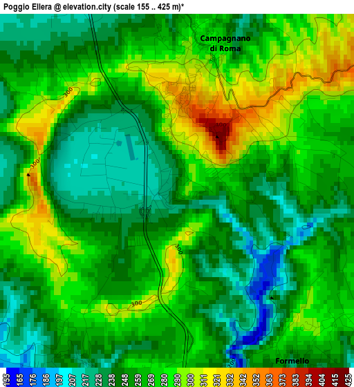
Below is the Elevation map of Poggio Ellera, which displays elevation range with different colors. Scale of the first map is from 155 to 425 m (509 to 1394 ft) with average elevation of 262.5 meters (=861 ft) [note 1]
These maps also provides idea of topography and contour of this city, they are displayed at different zoom levels. More info about maps, scale and edge coordinates you can find below images.
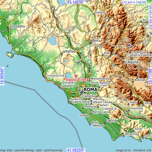
| \ | Map #1 | Topo.Map |
| Scale [m] | 155..425 m | × |
| Scale [ft] | 509..1394 ft | × |
| Average | 262.5 m = 861 ft | × |
| Width | 7.25 km = 4.5 mi | 232 km = 144.2 mi |
| Height | 7.25 km = 4.5 mi | 232 km = 144.2 mi |
| ↑Max Latitude | 42.146391° | 43.14838° |
| Latitude at center | 42.1138° | 42.1138° |
| ↓Min Latitude | 42.081192° | 41.06205° |
| ← Min Longitude | 12.327795° | 10.96549° |
| Longitude center | 12.37174° | 12.37174° |
| →Max Longitude | 12.415685° | 13.77799° |
Nearby cities:
Cities around Poggio Ellera sort by population:
• Anguillara Sabazia elevation 176 m
8.2 km,  242°
242°
• Campagnano di Roma 307 m
2.4 km,  3°
3°
• Cesano 189 m
5.3 km,  212°
212°
• Formello 171 m
6 km,  161°
161°
• Le Rughe 191 m
5 km,  175°
175°
• Sacrofano 216 m
6.4 km,  99°
99°
• Monterosi 278 m
10.6 km,  330°
330°
• Mazzano Romano 226 m
10.4 km,  10°
10°
• Monte Caminetto 108 m
9.9 km,  122°
122°
• Magliano Romano 266 m
7.2 km,  47°
47°
• Montelarco 249 m
10.8 km,  59°
59°
• Osteria Nuova 143 m
10 km, 211°
Multilingual:
 En español:
Poggio Ellera elevación 260 m.
 En France:
Poggio Ellera élévation 260 m.
 Auf Deutsch:
Poggio Ellera höhe über dem Meeresspiegel ist 260 m.

Sources and notes:
- [note 1] Map square and city borders are not equal. Map elevation data is calculated only from area inside that square.
- [src 1] Elevation data from geonames database provided with same terms of usage.
- [src 2] The elevation map of Poggio Ellera is generated using elevation data from NASA's 3 arcsec (90m) resolution SRTM data.
- [src 3] Base (background) map © OpenStreetMap contributors tiles are generated by Geofabrik and OpenTopoMap.
Copyright & License:
This Poggio Ellera Elevation Map is licensed under CC BY-SA. You may reuse any part from this page, if you give a proper credit by linking to this URL:
 More info on terms of use page.