Sacrofano elevation
Sacrofano (Latium, Città metropolitana di Roma Capitale), Italy elevation is 216 meters and Sacrofano elevation in feet is 709 ft above sea level [src 1]. Sacrofano is a seat of a third-order administrative division (feature code) with elevation that is 106 meters (348 ft) smaller than average city elevation in Italy.
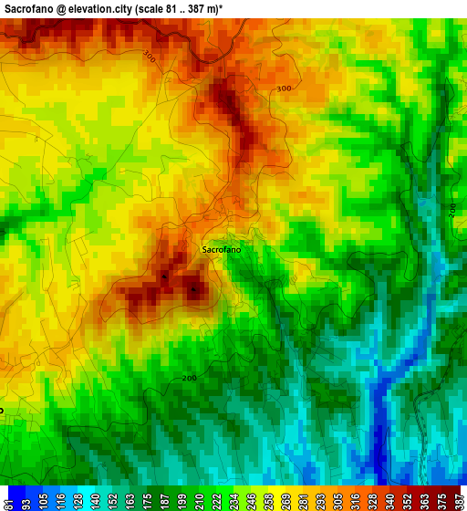
Below is the Elevation map of Sacrofano, which displays elevation range with different colors. Scale of the first map is from 81 to 387 m (266 to 1270 ft) with average elevation of 234.1 meters (=768 ft) [note 1]
These maps also provides idea of topography and contour of this city, they are displayed at different zoom levels. More info about maps, scale and edge coordinates you can find below images.
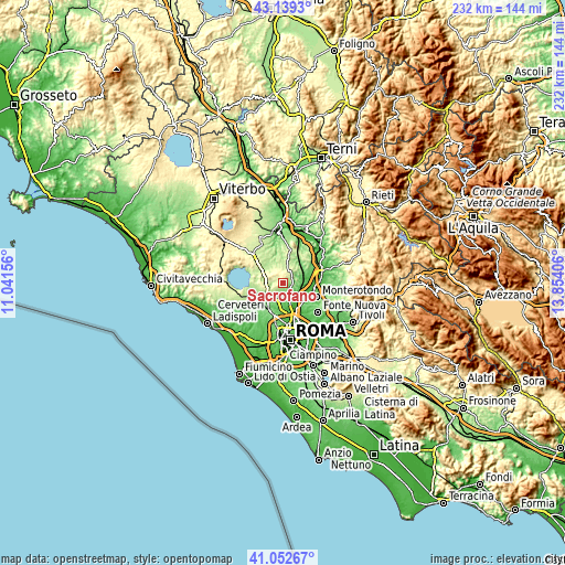
| \ | Map #1 | Topo.Map |
| Scale [m] | 81..387 m | × |
| Scale [ft] | 266..1270 ft | × |
| Average | 234.1 m = 768 ft | × |
| Width | 7.25 km = 4.5 mi | 232 km = 144.2 mi |
| Height | 7.25 km = 4.5 mi | 232 km = 144.2 mi |
| ↑Max Latitude | 42.137166° | 43.1393° |
| Latitude at center | 42.10457° | 42.10457° |
| ↓Min Latitude | 42.071958° | 41.05267° |
| ← Min Longitude | 12.403865° | 11.04156° |
| Longitude center | 12.44781° | 12.44781° |
| →Max Longitude | 12.491755° | 13.85406° |
Nearby cities:
Cities around Sacrofano sort by population:
• Campagnano di Roma elevation 307 m
7 km,  299°
299°
• Riano 136 m
5.6 km,  102°
102°
• Morlupo 231 m
6.8 km,  42°
42°
• Capena 153 m
9.1 km,  62°
62°
• Formello 171 m
6.4 km,  223°
223°
• Castelnuovo di Porto 179 m
5.5 km,  68°
68°
• Le Rughe 191 m
7.1 km,  236°
236°
• Monte Caminetto 108 m
4.7 km,  153°
153°
• Costaroni 131 m
7.9 km,  111°
111°
• Magliano Romano 266 m
6 km,  351°
351°
• Montelarco 249 m
7.2 km,  24°
24°
• Poggio Ellera 260 m
6.4 km,  279°
279°
Multilingual:
 En español:
Sacrofano elevación 216 m.
 En France:
Sacrofano élévation 216 m.
 Auf Deutsch:
Sacrofano höhe über dem Meeresspiegel ist 216 m.

Sources and notes:
- [note 1] Map square and city borders are not equal. Map elevation data is calculated only from area inside that square.
- [src 1] Elevation data from geonames database provided with same terms of usage.
- [src 2] The elevation map of Sacrofano is generated using elevation data from NASA's 3 arcsec (90m) resolution SRTM data.
- [src 3] Base (background) map © OpenStreetMap contributors tiles are generated by Geofabrik and OpenTopoMap.
Copyright & License:
This Sacrofano Elevation Map is licensed under CC BY-SA. You may reuse any part from this page, if you give a proper credit by linking to this URL:
 More info on terms of use page.