Trevignano Romano elevation
Trevignano Romano (Latium, Città metropolitana di Roma Capitale), Italy elevation is 174 meters and Trevignano Romano elevation in feet is 571 ft above sea level [src 1]. Trevignano Romano is a seat of a third-order administrative division (feature code) with elevation that is 148 meters (486 ft) smaller than average city elevation in Italy.
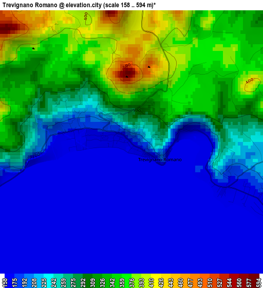
Below is the Elevation map of Trevignano Romano, which displays elevation range with different colors. Scale of the first map is from 158 to 594 m (518 to 1949 ft) with average elevation of 256 meters (=840 ft) [note 1]
These maps also provides idea of topography and contour of this city, they are displayed at different zoom levels. More info about maps, scale and edge coordinates you can find below images.
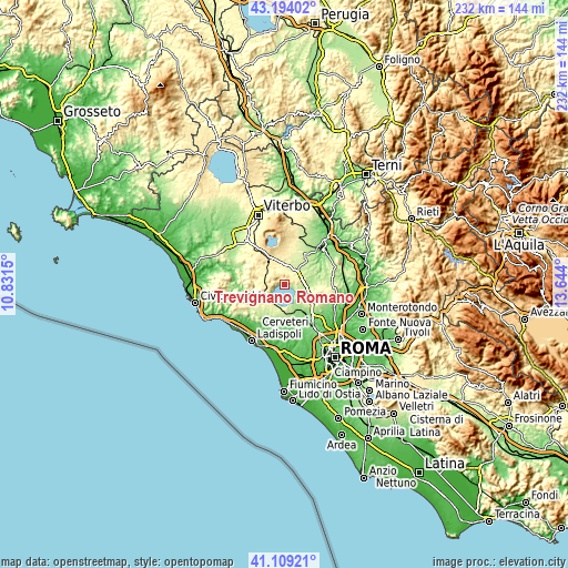
| \ | Map #1 | Topo.Map |
| Scale [m] | 158..594 m | × |
| Scale [ft] | 518..1949 ft | × |
| Average | 256 m = 840 ft | × |
| Width | 7.24 km = 4.5 mi | 231.8 km = 144 mi |
| Height | 7.24 km = 4.5 mi | 231.8 km = 144 mi |
| ↑Max Latitude | 42.192767° | 43.19402° |
| Latitude at center | 42.1602° | 42.1602° |
| ↓Min Latitude | 42.127616° | 41.10921° |
| ← Min Longitude | 12.193805° | 10.8315° |
| Longitude center | 12.23775° | 12.23775° |
| →Max Longitude | 12.281695° | 13.644° |
Nearby cities:
Cities around Trevignano Romano sort by population:
• Anguillara Sabazia elevation 176 m
9.8 km,  157°
157°
• Bracciano 314 m
8.7 km,  222°
222°
• Campagnano di Roma 307 m
11.5 km,  103°
103°
• Nepi 222 m
12.6 km,  43°
43°
• Manziana 358 m
9.9 km,  250°
250°
• Capranica 386 m
12.2 km,  333°
333°
• Sutri 311 m
9.7 km,  349°
349°
• Bassano Romano 374 m
8 km, 329°
• Oriolo Romano 415 m
8.2 km,  271°
271°
• Monterosi 278 m
7.1 km,  54°
54°
• Canale Monterano 380 m
11.4 km,  256°
256°
• Poggio Ellera 260 m
12.2 km,  115°
115°
Multilingual:
 En español:
Trevignano Romano elevación 174 m.
 En France:
Trevignano Romano élévation 174 m.
 Auf Deutsch:
Trevignano Romano höhe über dem Meeresspiegel ist 174 m.

Sources and notes:
- [note 1] Map square and city borders are not equal. Map elevation data is calculated only from area inside that square.
- [src 1] Elevation data from geonames database provided with same terms of usage.
- [src 2] The elevation map of Trevignano Romano is generated using elevation data from NASA's 3 arcsec (90m) resolution SRTM data.
- [src 3] Base (background) map © OpenStreetMap contributors tiles are generated by Geofabrik and OpenTopoMap.
Copyright & License:
This Trevignano Romano Elevation Map is licensed under CC BY-SA. You may reuse any part from this page, if you give a proper credit by linking to this URL:
 More info on terms of use page.